
NCERT Solutions | Class 12 Geography (India People and Economy) Chapter 10 | Transport And Communication

CBSE Solutions | Geography Class 12
Check the below NCERT Solutions for Class 12 Geography (India People and Economy) Chapter 10 Transport And Communication Pdf free download. NCERT Solutions Class 12 Geography were prepared based on the latest exam pattern. We have Provided Transport And Communication Class 12 Geography NCERT Solutions to help students understand the concept very well.
NCERT | Class 12 Geography (India People and Economy)
| Book: | National Council of Educational Research and Training (NCERT) |
|---|---|
| Board: | Central Board of Secondary Education (CBSE) |
| Class: | 12 |
| Subject: | Geography |
| Chapter: | 10 |
| Chapters Name: | Transport And Communication |
| Medium: | English |
Transport And Communication | Class 12 Geography | NCERT Books Solutions
Class 12 Geography Chapter 10 Important Extra Questions Transport and Communication
Transport and Communication Important Extra Questions Very Short Answer Type
Question 1.
Answer:
42 lakh kms.Question 2.
Answer:
Silchar and Porbandar.Question 3.
Answer:
National Highway no 7- (Varanasi to Kanniyakumari).Question 4.
Answer:
125 km.Question 5.
Answer:
1,15,000 km.Question 6.
Answer:
17.Question 7.
Answer:
In 1997.Question 8.
Answer:
In 1927.Question 9.
Answer:
Polar Satellite Launch Vehicle.Question 10.
Answer:
15 September, 1959.Question 11.
Answer:
Global, national, regional and local.Question 12.
Answer:
Physical (Postal Services), through Telegraph and through Airwaves.Question 13.
Answer:
Prom Varanasi to Kanniyakumari—2,369 km.Question 14.
Answer:
- The Highest road density—Kerala (387 per 100 sq. km.)
- The lowest road density Jammu & Kashmir— (3.5 km per 100 sq. km.)
Question 15.
Answer:
- Over long distances deliver items quickly.
- Require less time.
Question 16.
Answer:
(1) Indian National Satellite System (INSAT).(2) Indian Remote Sensing Satellite System (IRS)
Question 17.
Answer:
International and domestic.Question 18.
Answer:
New Delhi.Question 19.
Answer:
Kolkata Seaport and Nepal Sea Port.Question 20.
Answer:
Air India.Question 21.
Answer:
National Highways.Question 22.
Answer:
(a) Maharashtra – Nhava Sheva(b) Tamil Nadu – Ennore.
Question 23.
Answer:
It is difficult to construct roads due to hilly terrain of the area.Question 24.
Or
What are the major functions of the National Highways Authority of India?
Or
Which is the apex body responsible to improve the quality of roads at National level in India?
Answer:
To improve the quality of National Highway.Question 25.
Answer:
Pawan Hans Helicopters.Question 26.
Answer:
Amritsar.Transport and Communication Important Extra Questions Short Answer Type
Question 1.
Answer:
- Railways
- Roadways
- Airways
- Waterways
- Pipelines.
Question 2.
Answer:
Disadvantages of Road Transport.- Road transport is costly.
- It results in air pollution.
- Heavy goods cannot be taken to long distance.
- Road transport is more accident prone.
Question 3.
Or
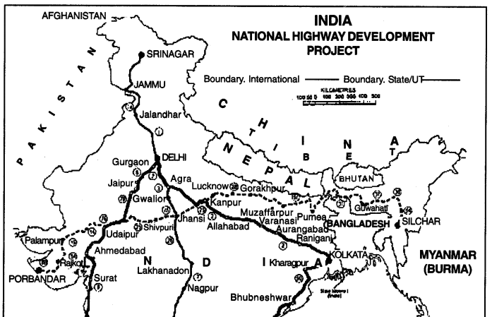
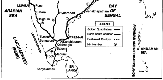
Explain the term ‘Gloden Quadrilateral.
Answer:
It is a super-highway project linking Delhi, Kolkata, Chennai and Mumbai. It has six super highways. It forms the shape of a Quadrilateral.Question 4.
Answer:
(i) Sher Shah Suri Marg. National Highway No. 1. (Delhi to Amritsar)(ii) National Highway No. 3. Between Agra and Mumbai.
(iii) National Highway No. 7. Between Varanasi and Kanniyakumari.
(iv) National Highway No. 2. Between Delhi and Kolkata.
Question 5.
Answer:
1. National Waterway No. 1. Pravagraj Haldia on Ganga river.2. National Waterway No. 2. Sadiya to Dhubri or Brahmaputra.
Question 6.
Answer:
Rail TransportIndian railway system is the main artery of the country’s inland transport. It is the biggest in Asia and the fourth largest in the world. It has a route length of 63221 km on which 12,670 trains run every day connecting 7,500 stations. Indian railways comprise of three gauges: broad gauge (1.616 metres is the distance between both the lines); metre gauge (1.00 metre) and narrow gauge (0.762 and 0.610 metres). Its fleet of locomotives comprises of steam, diesel and electric engines.
Different parts of railways having different width have been constructed in India due to its diverse relief. Broad gauge railway lines are constructed in plains while narrow gauge railway lines are constructed in hilly region.
- Broad gauge = 1.6 metres wide
- Metre gauge = 1 metre wide
- Narrow gauge = 0.76 metre wide.
| Gauge | Total route | Percentage |
| Broad | 46.887 km | 71.11% |
| Metre | 13,210 km | 21.27% |
| Narrow | 3,124 km | 94% |
| Total | 63,221 | 100% |
Question 7.
Answer:
The air services In India are of two types viz. international and domestic. Air India provides international air services for both passengers and cargo traffic to 35 destinations from four focal points—Delhi, Mumbai, Chennai and Kolkata. Air India carried 3.83 million passengers in 2000-01.Major international air routes are Delhi-Rome-Frankfurt, Mumbai-London, Delhi-Moscow, Kolkata-Tokyo, Kolkata-Perth, Mumbai- London-New York. Indian Airlines, Affiance Air (subsidiary of Indian Airlines), private scheduled airlines and air taxis provide domestic air services.
Indian Airlines operations also extends to the neighbouring countries of Southeast Asia and West Asia. At present, there are two private scheduled airlines operating on the domestic network; 38 companies hold non-scheduled air taxi operators permit. Private operators presently cater to nearly 52.8 per cent of the domestic air traffic. The share of private sector airways has increased rapidly after liberalisation.
Question 8.
Answer:
The railways in India are of three gauages— Broad gauge, metre gauge and narrow gauge. The metre gauge is being converted into broad gauge. This is called unigauge project. It avoids the transhipment of goods from one gauge to another. It will increase the capacity of transportation by trains and will he cheaper also.We have already noted that Indian Railways operate on three different gauges. This poses problems in the smooth flow of goods and passengers. The shift from one gauge line to the other involves unloading and transhipment which is time-consuming and expensive. The perishable commodities cannot withstand such a delay. Moreover, the passenger and freight traffic has been increasing day by day. The tracks are not suitable to take the heavy loads.
Question 9.
Answer:
Communication network carries information from one place to another physically like postal services, through wires like telegraph and telephone, or through airwaves like radio and television. Some communication systems work in cooperation with transport system like postal services. Others, however, function independent of the transport system such as radio.Question 10.
Or
“India has one of the largest network of roads in the world.” Support the statement with examples.
Answer:
Roads. The road network in India is one of the largest in the world. The road length has increased from 397.62 thousand kilometres in 1950-51 to around 42 lakh kilometres. Of the total kilometreage, the length of the surfaced (metalled) roads increased from 156.11 thousand kilometres in 1950-51 to 833.0 thousands kilometres while the unsurfaced (unmetalled) road length during the same period increased from 241.5 thousand kilometres to 940 thousand kilometres.National Highways. A number of important National Higways in India run in north-south and east- west directions. They link one part with the other
- Sher Shah Suri Marg is historically very important. It connects Kolkata with Peshawar. It is now known as National Highway 1, which links Delhi and Amritsar,
- National Highway 2 which links Delhi and Kolkata
- National Highway 3 runs between Agra and Mumbai via Gwalior, Indore and Nasik.
- National Highway 7 is the longest one which links Varanasi with Kanniyakumari via Jabalpur, Nagpur, Hyderabad, Bangalore and Madurai. It traverses a distance of 2,325 km.
- National Highways 5 and 17 run along the eastern and western coasts respectively.
- National Highways 15 represents the border road in Rajasthan desert and run through Kandla, Jaisalmer, Bikaner and joins the border road in Punjab.
Question 11.
Answer:
Indian Railways run six units to manufacture rolling stock. These are :(i) Chittaranjan Locomotive Works, Chittaranjan
(ii) Diesel Locomotive Works, Varanasi
(iii) Integral Coach Factory, Perambur
(iv) Rail Coach Factory, Kapurthala
(v) Wheel and Axle Plant, Bangalore, and
(vi) Diesel Component Works, Patiala.
Question 12.
Answer:
The Inland Waterways Authority of India was set up in 1986 for the development, maintenance, and regulation of National Waterways in the country. At present, there are only three National Waterways in the country. Ten other waterways are being considered for upgradation as National Waterways.The three national Waterways are:
- National Waterway 1 : The Allahabad-Haldia stretch of the Ganga-Bhagirathi Hooghly river system (1620 km);
- National Waterways 2 : The Sadiya-Dhubri stretch of the Brahmaputra river (891 km);
- National Waterways 3 : The West Coast Canal from Kottapuram to Kollam alongwith Udyogmandal and Champakar canals (205 km).
Question 13.
Answer:
Akashvani : Radio is an effective means of mass communication in the country. Radio broadcasting started in India in 1927 with two private transmitters located at Mumbai and Kolkata. All India Radio (AIR) was constituted in 1936. It is also known as Akashvani. At the time of Independence there were six radio stations. At present, the All India Radio has 208 stations and 327 transmitting centres.These stations and transmitting centres provide services to 99 per cent of the population and 90 per cent of the area of the country. Private parties also have set up about 100 FM radio stations. All India Radio broadcastes a variety of programmes like information, education and entertainment.
Question 14.
Answer:
Doordarshan: Doordarshan, the national television of India, is one of the largest terrestrial networks in the world. It has changed socio-cultural life of the people both in villages and in towns. DD-1 operates through a network of 1,042 terrestrial transmitters that reaches to over 87 per cent of the population.There are 65 additional transmitters giving terrestrial support to other channels. First telecast by Doordarshan was made on 15 September, 1959. Television was confined to certain cities up to 1975. The first experiment with satellite technology in India known as the Satellite Instructional
Television Experiment (SITE), was conducted in 1975-76. National programme and use of colour television could be started in the country only by 1992. Afterwards, television facility expanded very rapidly.
All India Radio has introduced commercial programmes also. Vivid Bharati channels have commercial broadcasting. Besides Vividh Bharati, other channels and local stations also provide commercial services. For rtiral audiences, several programmes are regularly transmitted.
Similarly, programmes on family welfare and healthcare are broadcasted every day. Music and drama are major components of the schedule of broadcasting. All India Radio commissioned the National Channel in 1998, which is essentially a night service, airing evening to morning broadcast.
Question 15.
Answer:
Air transport terminals are called airports. Air transport cost is comparatively very high, and therefore, it is mainly used for passenger services. Only light and valuable cargo is dispatched by cargo aircraft. In order to help Indian exporters and make their export more competitive, the Government of India introduced the ‘open sky policy5 for cargo. Under this policy any foreign airlines or association of exporters can bring freighters to the country for upliftment of cargo.Question 16.
Answer:
Sher Shah Suri built the Shahi (Royal) road to strengthen and consolidate his empire from the Indus Valley to the Sonar Valley in Bengal. This road was renamed the Grand Trunk (GT) road during the British period, connecting Calcutta and Peshawar. At present, it extends from Amritsar to Kolkata. It is bifurcated into 2 segments:- National Highway (NH)- 1 from Delhi to Amritsar, and
- NH-2 from Delhi to Kolkata.
Question 17.
Or
Describe any three features of Konkan Railway.
Answer: Konkan Railway. One of the important achievements of Indian Railways has been the construction of Konkan Railway in 1998. It is 760 km long rail route connecting Roha in Maharashtra to Mangalore in Karnataka. It is considered an engineering marvel.
It crosses 146 rivers, streams, nearly 2000 bridges and 91 tunnels. Asia’s largest tunnel which is nearly 6.5 km long, also lies on this route. The states of Maharashtra, Goa and Karnataka are partners in this undertaking.
Question 18.
Answer:
- India has one of the largest road network in the world.
- The total length of roads in India is 42 lakh kms.
- About 85% of passenger and 70 percent of freight traffic is carried by roads.
- Roads continue to concentrate in and around urban centres.
- Rural areas have the least km of roads.
- 5846 km long Golden Quadrilateral network connects Delhi, Chennai, Kolkata and Mumbai.
Question 19.
Answer:
Internet is the most effective and advanced personal communication system in India.Characteristics.
- It is widely used in urban areas.
- It connects the user through E-mail with the world.
- It is widely used for e-commerce and carrying out money transactions.
- It is a store house of detailed data.
Question 20.
Or
Why is the distribution of roads not uniform in India? Explain with l examples. (CBSE2016)
Answer:
The distribution of roads is not uniform in the country. The level of economic development and nature of terrian are the main determinants of density of roads.- Construction of roads is easy and cheaper in plain area.
- Quality of roads is better in plains, as compared to roads in high altitude areas.
- The density of road is 10.48 km in Jammu and Kashmir (including Ladakh) where as it is 387.24 km in Kerala (a plain area).
- The density of roads is high in northern states due to the high level of economic development.
Question 21.
Or
Describe any five characteristics of national Highway of India.
Answer:
National Highway: The main roads which are constructed by the Central Government are known as the National Highways.- These are meant for inter-state transport.
- These help in movement of defence goods and material in strategic areas.
- These connect the state capitals, major cities ports, railway junctions, etc.
- These carry 40% of road traffic, while these ae only 2% of the total road length.
Question 22.
Answer:
A dense network of railways is developed in the north Indian plains. About 50% of the total length of railways in India is found in northern India. The northern railways is the longest railway with a length of 10,977 kms. Many physical and economic factors are responsible for it.- Northern plain is a level plain with low altitude. It is best suited for the construction of railways.
- Due to dense population, big towns have developed which has led to high density of railway.
- The intensive development of agriculture and industries has promoted the construction of railway lines.
- It is essential to connect Mumbai and Kolkata with their hinterlands or northern plain.
Question 23.
Or
Which apex body develop the border roads ? Explain the importance of border roads with examples.
Answer:
Looking at the strategic importance of our border areas, the Border Roads Organisation was set up in 1960 and entrusted with the construction and maintenance of roads in the border states of the country. These border roads have helped in accelerating the economic development in these areas by increasing accessibility besides helping in strengthening of the defence preparedness.It includes the highest road of the world from Manali to Leh, at an altitude of 4220 metres above sea level. Along Indo-Chinese border, Hindustan Tibetan Road has been constructed. The board has constructed about 22800 km of Border roads and manages above 16400 km. of roads in border area.
Question 24.
Answer:
Punjab has the highest density of surfaced roads. The density of roads is 74 km. per 100 sq. km. It is due to the following factors:(1) Punjab plain is a gently sloping alluvial plain. It is easy to construct roads.
(2) Punjab is an agriculturally developed state. For the easy and quick movements of agricultural products, roads have been constructed.
(3) Punjab exports wheat, rice and other crops to other parts of India. Therefore quick means of transportation is required.
(4) The per capita income of people and the standard of living is quite high. So the state needs a lot of manufactured goods and raw materials. Roads provide door to door service.
(5) The movement of passenger traffic is high. So, roads are required especially for the rural areas.
Question 25.
Answer:
Transport network is established to facilitate the movement of people and goods. It is the means of bringing human beings and the things they need and use together. It functions as a lifeline of the spatial economy at all territorial levels: A transport system involves origin, destination, route and the carrier.- Origin. Origin is the point where the traffic originates.
- Destination. Destination is the point where it terminates.
- Route. Route is the surface on which movement takes place.
- Carrier. The carrier is the vehicle that moves the passenger or cargo. A well-knit and coordinated system of transport plays an important role in the sustained economic growth of the country.
Question 26.
Answer:
In India, the growing importance of road transport vis-a-vis rail transport is rooted in following reasons:- Construction cost of road is much lower than that of railway line
- Roads can traverse comparatively more dissected and undulating topography
- Road transport can economically carry few persons and relatively small amount of goods.
- Cost of loading and unloading is much lower in case of road transport, because it provides door-to-door service.
- Road transport also supplements other modes of transportation. It provides link between railway stations and airports and their hinterlands.
Question 27.
Answer: Indian Railways :
(i) Indian railways network is one of the longest in the world.
(ii) It facilitates the movement of both freight and passengers. The total freight carried by railways is 557.39 million tonnes. The total number of passengers carried by railways is 5112 million.
(iii) Metro rail has revolutionised the urban transport system in Kolkata and Delhi.
(iv) Railways developed around towns, raw material producing areas, hill stations have been developed for the exploitation of resources.
(v) Railways could run to remain the main means of transport for the masses.
Question 28.
(a) Personal communication and
(b) Mass communication.
Or
Classify means of communication on the basis of scale and quality into two categories. Explain any two characteristics of each category. (Outside Delhi C.B.S.E. 2017)
Answer:
| Personal Communication | Mass Communication |
| 1. Personal communication are the means of delivering messages belween individuals or small groups.
2. Messages are carried between the sender and the receiver both ways. 3. These means of communication include post card, letter, telegram. fax, telephone. |
1. These are the means of delivering messages from an individual or a group to a large audience.
2. Messages are delivered from a sender to a large audience usually oneway. 3. These means of communic. ion include newspapers, magazines and other periodicals, electronic media like radio, television, films, etc. |
Question 29.
Answer:
| National Highways | State Highways |
| 1. These are the major roads of the whole country.
2. These connect the different capitals of state with major industrial and commercial towns of the country. 3. These are maintained by the Central Govt. 4. Total length of national highways in India is 71,000 kms. 5. These have commercial and strategic significance; 6. Sher Shah Suri Marg (G.T. Road) is a national highway. |
1. These are the major roads within a state.
2. These connect the state capitals with the major towns and district head- quarters within a state. 3. These are maintained by the State Govt. 4. The total length of state highways is 1,37,712 kms. 5. These have administrative signifi-cance. 6. Amritsar-Chandigarh is a state highway. |
Question 30.
Answer:
Border roads are strategically important roads along the Northern and North-eastern boundary of the country.(i) These are roads in high altitudes and mountainous areas.
(ii) These are contructed and maintained by BRO (Border Road Organisation).
Question 31.
Answer:
Advantage of Satellite CommunicationSatellite communication is vital for the country due to economic and strategic reasons:
(i) They are significant means of communication.
(ii) These can be used for the weather-forecast, monitoring of natural calamities, surveillance of border areas.
(iii) This is useful in the management of natural resources.
Question 32.
Answer:
(i) The density of roads varies from only 10.48 km in Jammu and Kashmir (including Ladakh) to 387.24 km in Kerala.(ii) Nature of topography is the main basis of road density.
(iii) Construction of roads is easy and cheaper on plains, while it is expensive on hilly terrain.
Question 33.
Answer:
(i) Pipelines are used to transport liquids and gases.(ii) It is environmental-friendly means of transport.
(iii) Pipelines can be laid through difficult terrain and also under water.
Question 34.
Answer:
Communication is an activity of conveying information through the exchange of thoughts, messages or information by speech, visual, writing or behaviour.Importance of Telecommunication:
- Telecommunication is an important tool for busines. This device is used to receive and send messages, access data etc.
- This refers to the exchange of information with electronic and electrical means over a long distance.
- Telecommunication also useful for students.
- Telecommunication is helpful for people living in areas that do not have special care facility. With this they get in touch with a healthcare provider.
- Telecommunication play a vital role in transport sector.
Transport and Communication Important Extra Questions Long Answer Type
Question 1.
Answer:
Distribution of Railways. A close look at the railway map of India in any atlas would reveal the following pattern of the railway network:(1) Northern plains. A dense network of railways has been developed in the Northern Indian Plain from Amritsar to Howrah with a few focal points like Delhi- Kanpur-Mughal Sarai, Lucknow, Agra and Patna.
The whole of Northern Plain is very well connected. While connectivity is more efficient in east-west direction, it is not so efficient in the north and south direction from the trunk routes. The rail network in this plain is highly correlated to the level of agricultural and industrial development. Delhi is the focal point from where railway lines radiate in all directions. It is connected with ports through superfast trains.
Many favourable factors have led to development of a dense network of railways in Northern Plains.
Favourable factors. A dense network of railways is developed in the north Indian plains. About 50% of the total length of railways in India is found in northern India. The northern railways is the longest railway with a length of 10,977 kms. Many physical and economic factors are responsible for it.
- Northern plain is a level plain with low altitude. It is best suited for construction of railway.
- Due to dense population, big towns have developed which have led to high density of railway.
- The intensive development of agriculture and industries h as promoted the construction of railway lines.
- It is essential to connect Mumbai and Kolkata with their hinterlands of northern plain.
(2) Peninsular plateau. The peninsular region, Gujarat and Tamil Nadu have a denser rail network as compared to other parts. The whole of the peninsular region has a hilly and plateau terrain. The concentration of population is moderate. Therefore, the rail network is also sparse. Trunk routes are aligned in such a way that there are efficient connections between Mumbai-Chennai, Chennai-Cochin, Chennai- Delhi and Chennai-Hyderabad.
(3) Coastal plains. There is a distinct contrast in the rail network between eastern coastal plains and western coastal plains. There exists a long trunk route all along the east coast. Such a rail track is the Konkan Railway of 837 km. long which has been built along the western coast from Mumbai to Cochin.
The outcrops of the Western Ghats being very close to the coast, restrict the extent of the coastal plain while the eastern coast is wider and the Ghats lie away from the coast.
(4) Areas with sparse Rail network. Himalayas, west Rajasthan, Brahmaputra valley, North East hilly region have sparse rail-network.
(a) Himalayan Region. The mountainous terrain of the Himalayas is such a noteworthy region. The rugged terrain, hill and valley topography, backward economy and sparse population are the factors responsible for the sparse rail network in this region.
(b) Western Rajasthan. In western Rajasthan a few metre gauge railway lines have penetrated the arid tract.
(c) Brahmaputra valley. The Brahmaputra Valley has two parallel lines but no railway line has been constructed on the Meghalaya plateau.
(d) N.E. Region. In Tripura, Mizoram, Manipur and Nagaland, no railways have been constructed. The main reasons for the absence of a railway network are the hilly terrain and forested tracts. The cost involved in providing railway tracks in these regions is too high. The sparse population is another important aspect which has not encouraged this investment.
Question 2.
Answer:
(1) Naharkatiya Barauni pipeline. Oil India Limited constructed the first pipeline of 1,152 km from Naharkatiya oilfield in Assam to Barauni refinery in Bihar via Noonmati (1962-68).2. Haldia-Kanpur pipeline. To transport refined petroleum products. Barauni-Kanpur pipeline was laid down in 1966. Haldia-Maurigram-Rajbandh pipeline was constructed later.
3. Ankleshwar-Koyali pipeline. Extensive network of pipelines has been constructed in the Gujarat region. First pipeline connected the Ankleshwar oilfield to Koyali refinery (1965). Later, Kalol-Sabarmati crude pipeline, the Navagaon-Kalol-Koyali pipeline and the Mumbai High-Koyali pipeline were laid.
4. Ahmedabad-Koyali pipeline. Ahmedabad has been linked with Koyali by pipeline for transport of petroleum products.
5. Ankleshwar-Vadodara pipeline. Gas pipelines have also been laid down between Khambhat and Dhuvaran, Ankleshwar and Uttaran, and Ankleshwar and Vadodara. Gas Authority of India Limited (GAIL) operates over 4,200 km of pipeline in the country and supplies gas to power plants.
6. HBJ gas pipeline. Construction of a cross country 1,750 km long Hazira-Bijapur-Jagdishpur (HBJ) pipeline has already been completed. This pipeline has now been extended from Bijapur to Dadri in Uttar Pradesh.
7. Kandla-Delhi pipeline. GAIL is also implementing a 1,246 km long LPG pipeline project from Kandla/Jamnagar in Gujarat to Luni in Uttar Pradesh via Delhi.
8. Mathura-Jalandhar pipeline. The Mathura refinery gets its crude from the Mumbai High through pipeline, which extends from Salaya on the Gulf of Kachchh to Mathura, Petroleum product supply pipeline exists between Mathura and Jalandhar via Delhi and Ambala, and between Mumbai and Pune for the transport of petroleum products.
Question 3.
Answer:
The history of roads construction in India is very old. Sher Shah Suri constructed Grand Trunk Road. After independence, a 10 year road development scheme known as the Nagpur Plan, was prepared. Four types of roads are found in India:(i) National Highways (79,243 km)
(ii) State Highways (1,31,899 km)
(iii) District Roads (4,67,763 km)
(iv) Village Roads (26,50,000 km)
Main features of Roads in India:
(1) India has 13,94,000 kms of metalled roads.
(2) India has 8,73,500 kms of unmetalled roads.
(3) India has just 41 km. road length for every
100 sq. km. area. It has a road length of 251 km for every 1 lakh people.
(4) India has 79,243 kms of National highways.
(5) About 26 lakh automobiles move on roads of India.
(6) Annual income from roads is about 1500 crore rupees.
(7) Indian roads carry about 30% of total freight of the country.
(8) The important National highways are:
- Sher Shah Suri Marg (G.T. Road) Kolkata to Jammu.
- Delhi-Mumbai Road
- Kolkata-Mumbai Road
- Mumbai-Chennai Road
- Great Deccan Road (Varanasi to Kanyakumari)
- Kolkata-Chennai Road.
- Pathankot-Srinagar Road.
- The Border Road Development Board was established in 1960.
It has got constructed about 38,028 km. long metalled roads in border areas. It has constructed the world’s highest road from Manali (H.P.) to Leh (Ladakh). The average height of this road is 4,270 metres.
Question 4.
Answer:
Railways in India. The first railway line was constructed between Mumbai and Thane in the year 1853. It was only 34 km. long. Railways are the chief means of transport in India.Main Characteristics:
- Indian Railways have a total length of 62,759 kms.
- It is the largest railway system in Asia and the fourth largest in the world.
- More than 18 lakh workers are engaged in Indian railways.
- Indian railways have about 12,670 trains which operate over 6,867 stations for a distance of 13 lakh kms.
- These railways carry 130 lakh passengers and 13 lakh tons freight daily.
- Railways have an investment of a capital of 8.0 crore rupees and yield an annual income of ? 21,000 crore.
- Indian railways have about 11,000 locomotives,38.0 coaches and 4 lakh wagons.
- Most of the railways are found in the level Gangetic plain.
- Railways have not been extensively developed in Jammu-Kashmir and Ladakh N.E. India, Western ghats, Chhotta Nagpur Plateau and Thar Desert (Rajasthan).
- In Southern India, construction of railways is retarded due to hilly areas and rivers.
- India has 4,259 diesel locomotives, 2,302 electric locomotives and 347 steam locomotives. The electric trains run over a distance of 11,772 kms.
Indian railways run of three gauges:
- Broad gauge—1.67 metres wide (49%)
- Metre gauge—1 metre wide (44%)
- Narrow gauge—0.76 metre wide (7%)
During year 1996-97, seven new rail zones have been created out of existing ones. The four following zones have been started:
- North-Central with headquarters at Allahabad.
- Central-Eastern with headquarters at Hajipur (Bihar).
- North-Western with headquarters at Jaipur.
- West-Southern with headquarters at Bangalore.
- Central with headquarters at Jabalpur.
- Eastern with headquarters at Bhubneshwar.
- S.E. Central Railway at Bilaspur.
Question 5.
Or
Examine the role of inland waterway, authority of India. Explain why inland water transport is an important mode of transport.
Or
“Waterways is an important mode of transport for both passengers and cargo traffic in India.” Support the statement with examples.
Answer:
For the development, maintenance and regulation of natural waterways in India, the inland waterways authority was set up in 1986. It has identified 13 inland waterways which could be upgraded.Inland Waterways: Water transport is a cheaper means of transport and is suitable for carrying heavy and bulky materials. India is endowed with many navigable rivers and inland water bodies but the share of inland waterways is only one per cent in the country’s transport system.
(1) A total river length of 3,700 km. of major rivers is navigable by mechanised boats but only 1,700 km. of this length is utilised.
(2) We also have a network of about 4,300 km. of canals, of which a stretch of 485 km. is navigable by mechanised crafts but only 3.5 km. is actually utilised. It shows that the inland waterways are greatly underutilised.
(3) Ganga, Brahmaputra and their tributaries are navigable. The deltaic areas of Godawari, Krishna and Mahanadi, lower reaches of Narmada and Tapti, backwaters of Kera, Mondoai and Juari rivers of Goa are some of the major inland waterways.
(4) Buckingham canal in Andhra Pradesh and Tamil Nadu and the Cumberjua Canal are also important navigable canals. The policy for the development of inland waterways is formulated by Central Inland Water Transport Board, New Delhi. The national waterways are developed, maintained and managed by the Inland Waterways Authority of India (IWAI) which was set up in 1986. The national waterways
(Prayagraj-Haldia stretch of Ganga-Bhagirathi-Hugli River system) Act, 1982 has the provision that the regulation and development of this waterway is the responsibility of the Central Government. The river navigation services are operated for carrying goods between Kolkata and Assam, Kolkata and Farakka and Kolkata and Cachar, by Central Inland Water Transport Corporation, which is a Government of India undertaking.
Question 6.
Or
“The triple transport system plays an important role in strengthening the social, political economic unity of India.” Explain.
Answer:
Integrating role of transport. Means of transport are the lifeline of a country. A developed and efficient system of transport is vital for maintaining the sovereignty and economic unity of the country. Under the 20 years Nagpur Plan, a balanced and integrated transport system of rail, road and waterways has been aimed at. The different means of transport have played an integrating role in the political and economic unity of India.(i) These have connected far flung areas with one another. Leh has been connected with Kanniyakumari, while Assam has been connected with Kutch.
(ii) Means of transport distribute foodgrains, manufactured goods, raw materials and minerals to different parts of the country.
(iii) Pipelines supply petroleum and gas to different areas.
(iv) The commercialisation of agriculture, manufacturing growth of towns and cities have been achieved due to means of transport.
(v) The new road, railway lines have integrated the border areas with the rest of the country. Jawahar tunnel connects Kashmir valley with India.
(vi) Railways line through gaps in the Vindhyan- Satpura hills and in Western Ghats have provided easy connection between the North and South.
(vii) Ganga as a waterway has acted as a unifying agent right from U.P. to West Bengal. Thus, each means of transport has played its own role in a unified system of transport.
Question 7.
Answer:
Importance of Air TransportAir transport is the fastest but costliest mode of transport. It is an important mode for a country of the size of India where the terrain and the climatic conditions are so diverse and important commercial and industrial centres are located at great distances. It is vital for our internal transport system as well as for the links with other countries. India occupies a central location between western Europe and Africa on the one hand and South-East and East Asia, on the other.
Types of Air transport: The air transport in India has two sectors.
(i) Air India : The Air India handles the foreign traffic, both passengers and cargo from four focal points, Delhi, Mumbai, Chennai, Kolkata. It connects all the continents through its services. The Air India carried 21.33 lakh passengers in 1997-98.
(ii) Indian Airlines. The domestic traffic is handled by the Indian Airlines Corporation. It carries passengers, cargo and mail to different destinations within the country as well as to eight neighbouring countries.
(iii) Vayudoot. To augment the air transport in the country the Vayudoot airlines was set up in 1981. It generally provides links with remote and inaccessible areas which are not covered by the Indian Airlines.
(iv) Pawan Hans. In 1985, the Pawan Hans Limited was established to provide helicopter services in order to link far-flung and inaccessible areas in hilly and forested regions.
Question 8.
Or
Evaluate the utility of ‘Golden Quadrilateral.’
Answer:
Six types of Roads are formed in India :(i) Golden Quadrilateral Super Highways. A major road development project linking Delhi-Kolkata- Chennai-Mumbai by six-lane super highways. North South corridor links Srinagar with Kanya Kumari and The East-West corridor links Silchar with Porbandar. It is 5,846 km. long.
(ii) National Highways. They connect capitals and main towns. These are maintained by the Central Public Works Department (CPWD), are known as the National Highways. There was a road length of National Highways 79,243km in 2010-11.
(iii) State Highways : The States and Union territories also construct and maintain roads. The state capital is linked with the district headquarters by state highways. It has a total length of 1,31,899km. and is 20% of the total length of roads.
(iv) District Roads. These connect district headquarters of a state. It has a total length of 6 lakh kms. 4,67,763 km is the total length of district road.
(v) Rural Roads. The rural areas are inter-linked by rural roads, which are generally dusty tracks. It can safely be said that the lower the level of roads in its type-hierarchy the poorer the quality of the road.26,50,000 km is the total length.
(vi) Border Roads. The border roads organisation was set up in 1960 for the development of roads of strategic importance in Northern and North-eastern borders. It has completed 30,028 kms. roads inaccessible areas of difficult terrain.
Transport and Communication Important Extra Questions HOTS
Question 1.
Or
Why is the transport a vital sector of the economy ?
Answer:
A good network of roads, railways, waterways and airways are the lifeline of a country. The agricultural and economic development of a country depends upon efficient transport system. The development of means of transport is essential for the utilisation of natural resources. It is the basis of industries and trade of the country. It helps to join the far-flung regions into a single national economy.These also help in defending the independence and the national unity of a country. Just as the arteries supply blood to the different parts of human body, similarly, transport system maintains the movement of men and goods in different parts of the country.
Question 2.
Answer:
Railway Zones have been made to improve the efficiency of Railways. It helps in handling freight and passenger traffic.| S.No. | Zone | Headquarters |
| 1. | Eastern | Kolkata |
| 2. | Western | Mumbai |
| 3. | Northern | New Delhi |
| 4. | Southern | Chennai. |
Question 3.
Answer:
Importance(1) One of the important if water transportation is that it does not require route construction.
(2) The oceans are linked with each other and are negotiable with ships of various sizes.
(3) The energy cost of water transportation is lower. In ancient times, river ways were the main
highways of transportation in the case of India. But these last importance because.
- Competition from Railways
- Lack of water
- Poort maintenance of water bodies.
NCERT Class 12 Geography (India People and Economy)
Class 12 Geography Chapters | Geography Class 12 Chapter 10
Class 12 Geography NCERT Solutions: Fundamentals of Human Geography
NCERT Solutions for Class 12 Geography: Fundamentals of Human Geography
-
NCERT Solutions For Class 12 Geography Chapter 1 Human Geography (Nature and Scope)
NCERT Solutions For Class 12 Geography Chapter 2 The World Population (Distribution, Density and Growth)
NCERT Solutions For Class 12 Geography Chapter 3 Population Composition
NCERT Solutions For Class 12 Geography Chapter 4 Human Development
NCERT Solutions For Class 12 Geography Chapter 5 Primary Activities
NCERT Solutions For Class 12 Geography Chapter 6 Secondary Activities
NCERT Solutions For Class 12 Geography Chapter 7 Tertiary and Quaternary Activities
NCERT Solutions For Class 12 Geography Chapter 8 Transport and Communication
NCERT Solutions For Class 12 Geography Chapter 9 International Trade
NCERT Solutions For Class 12 Geography Chapter 10 Human Settlements
Class 12 Geography NCERT Solutions: India People and Economy
NCERT Solutions for Class 12 Geography: India People and Economy
-
NCERT Solutions For Class 12 Geography Chapter 1 Population: Distribution, Density, Growth and Composition
NCERT Solutions For Class 12 Geography Chapter 2 Migration: Types, Causes and Consequences
NCERT Solutions For Class 12 Geography Chapter 3 Human Development
NCERT Solutions For Class 12 Geography Chapter 4 Human Settlements
NCERT Solutions For Class 12 Geography Chapter 5 Land Resources and Agriculture
NCERT Solutions For Class 12 Geography Chapter 6 Water Resources
NCERT Solutions For Class 12 Geography Chapter 7 Mineral and Energy Resources
NCERT Solutions For Class 12 Geography Chapter 8 Manufacturing Industries
NCERT Solutions For Class 12 Geography Chapter 9 Planning and Sustainable Development in Indian Context
NCERT Solutions For Class 12 Geography Chapter 10 Transport And Communication
NCERT Solutions For Class 12 Geography Chapter 11 International Trade
NCERT Solutions For Class 12 Geography Chapter 12 Geographical Perspective on Selected Issues and Problems
Practical Work in Geography Class 12 Solutions
NCERT Solutions for Class 12 Geography: Practical Work in Geography
-
NCERT Solutions For Class 12 Geography Chapter 1 Data – Its Source and Compilation
NCERT Solutions For Class 12 Geography Chapter 2 Data Processing
NCERT Solutions For Class 12 Geography Chapter 3 Graphical Representation of Data
NCERT Solutions For Class 12 Geography Chapter 4 Use of Computer in Data Processing and Mapping
NCERT Solutions For Class 12 Geography Chapter 5 Field Surveys
NCERT Solutions For Class 12 Geography Chapter 6 Spatial Information Technology
Post a Comment
इस पेज / वेबसाइट की त्रुटियों / गलतियों को यहाँ दर्ज कीजिये
(Errors/mistakes on this page/website enter here)