
NCERT Solutions | Class 12 Geography (Fundamentals of Human Geography) Chapter 8 | Transport and Communication

CBSE Solutions | Geography Class 12
Check the below NCERT Solutions for Class 12 Geography (Fundamentals of Human Geography) Chapter 8 Transport and Communication Pdf free download. NCERT Solutions Class 12 Geography were prepared based on the latest exam pattern. We have Provided Transport and Communication Class 12 Geography NCERT Solutions to help students understand the concept very well.
NCERT | Class 12 Geography (Fundamentals of Human Geography)
| Book: | National Council of Educational Research and Training (NCERT) |
|---|---|
| Board: | Central Board of Secondary Education (CBSE) |
| Class: | 12 |
| Subject: | Geography |
| Chapter: | 8 |
| Chapters Name: | Transport and Communication |
| Medium: | English |
Transport and Communication | Class 12 Geography | NCERT Books Solutions
Class 12 Geography Chapter 8 Important Extra Questions Transport and Communication
Transport and Communication Important Extra Questions Very Short Answer Type
Question 1.
Answer:
First public railway line was opened in 1825 between Stockton and Darlington (England).Question 2.
Answer:
15 million kms.Question 3.
Answer:
Vancouver (British Columbia) and St. John (New foundland)Question 4.
Answer:
West Asia is the least developed in rail facilities because of sparsely populated and Vast deserts.Question 5.
Answer:
The Trans-Continental Stuart Highway.Question 6.
Answer:
Chengdu with Lhasa.Question 7.
Answer:
South Africa has largest rail network in Africa continent.Question 8.
Answer:
In U.K, U.S.A., Japan and India, millions of passengers daily move to and for in the city by commuter trains.Question 9.
Answer:
Belgium-1 km of railway for every 6.5 sq. km.Question 10.
Answer:
Channel Tunnel operated by Euro Tunnel group.Question 11.
Answer:
Trans Andean Railway connecting Valparaiso (Chile) with Buenos Aires (Argentina). It runs across the Andes through the Uspallatta Pass (3900 m length).Question 12.
Answer:
A train from Capetown to Pretoria in South Africa.Question 13.
Answer:
From Paris to Istanbul.Question 14.
Answer:
Port Said (North) and Port Suez (South).Question 15.
Answer:
Japan has the highest road density.Question 16.
Answer:
Port Colone and Panama.Question 17.
Answer:
St. Lawrence River-great lakes and Rhine waterway.Question 18.
Answer:
North Altantic ocean route.Question 19.
Answer:
Waterways.Question 20.
Answer:
Trans continental railway.Question 21.
Answer:
Big Inch pipeline.Question 22.
Answer:
West—PerthEast—Sydney.
Question 23.
Answer:
This was the first pipe fine constructed by I.O.L in 1956.Question 24.
(i) Rhine Water way
(ii) The Cape of good hope as a route
(iii) Suez Canal
(iv) Panama Canal.
Answer:
(iii) Suez Canal.Or
Which Inland waterway of the world is most heavily used.
Answer:
The Rine Inland waterway of the world in most heavily used.Question 25.
Answer:
Trans-Siberian Railway is the longest railway in the world. It has terminal station of Vladivostock (in the east) and St. Petersburg (in the west).Question 26.
Answer:
Pan American highway.Question 27.
Answer:
Road density in the length of roads per 100 sq. km. of area.Question 28.
Answer:
Volga is 3840 km long river in Russia and provide 11,200 km navigable able route. It joined Moscow and Ukraine through densely populated area.Transport and Communication Important Extra Questions Short Answer Type
Question 1.
Answer:
Transport is a service for the carriage of person and goods from one place to another.It uses humans, animals and vehicles. Such movements take place over land, water and air.
(i) Land transport includes roads and railways.
(ii) Water transport includes shipping and waterways.
(iii) Air transport includes high valued goods.
(iv) Pipelines carry petroleum, natural gas and liquids.
Question 2.
Answer:
The significance of a mode of transport depends upon :(i) Type of goods and services to be transported.
(ii) Costs of transport.
(iii) The mode which is available.
Question 3.
Answer:
Two types of roads are constructed :(i) Unmetalled roads
(ii) Metalled roads.
Unmetalled roads or surface roads are simple roads. These are not effective and serviceable for all seasons. In rainy season, these become unmotorable.
Metalled roads are laid with bricks and stones. These are solid roads. But during heavy rains and floods these, are damaged. High embankments are constructed to protect these.
Question 4.
Answer:
Roads laid along international borders are called border roads. They play an important role in integrating people in remote areas with the major cities. These provide defence needs. These are used to transport goods to border villages and military camps.Question 5.
Answer:
(i) It does not require route construction.(ii) The oceans are linked with each other.
(iii) These are negotiable with ships of various sizes.
(iv) The energy cost of water transport is low.
(v) It is the cheapest means of transport.
Question 6.
Answer:
The great lakes of North America, Superior, Huron Erie and Ontario are connected by Soo canal and Willand canal to form an Inland waterway. The Estuary of St; Lawrence River along with great lakes forms a commerical waterway.Question 7.
Answer:
The development of inland waterways depend upon the following factors :(i) Width and depth of channel
(ii) Continuous flow of water
(iii) Use of technology for dredging.
Significance of Rhine Inland Waterway: The Rhine flows through Germany and the Netherlands. It is navigable for 700 km from Rotterdam, at its north in the Netherland to Basel in Switzerland. It flows through a rich coalfield and the whole basin has become a prosperous manufacturing area. This waterway is the world’s most heavily used.
Question 8.
Answer:
Trans-Siberian Railway line connects the Ear East, the Ural region and the Siberian region with the European Russia. It has helped in the economic development of Siberia. Iron ore and machinery is sent to the Eastern region by this railway.Foodgrains, wood and coal are sent towards the western part from the Siberian region. Many navigable rivers join this railway line from North and South. Many industrial and commercial towns of Siberia are located on this railway fine. This railway line has helped in the utilisation of resources of Siberia and consequently the density of population has increased in this region.
Question 9.
Answer:
The two important inland waterways of Europe are Rhine waterway and Danube waterway. The following factors affect the inland waterways.(i) Navigability of waterway
(ii) Width and depth of waterway
(iii) Water flow
(iv) Transport technology.
Question 10.
Answer:
Panama Canal.1. It is located in Panama. U.S.A. has control over this canal.
2. It allows two way traffic.
3. It has lock system to allow the ships.
4. Less taxes are charged from the ships passing through this canal.
5. It connects the Atlantic Ocean and the Pacific Ocean.
6. Coal is not available in large quantity on this route.
7. It is important for U.S.A., as the ships do not have to go around Cape Horn.
Question 11.
Answer:
Trans-canadian railway line was constructed in 1886.- It runs across Canada from West to East.
- It connects Halifax and Victoria.
Question 12.
Answer:
- Suez canal is the longest navigation canal in the world.
- It was constructed in 1866 by French Engineer Ferdinand de Lesseps.
- Suez canal joins Red Sea with Mediterranean Sea.
- Suez canal has been called the lifeline of the British Empire.
- It is well served with coal and oil.
- This is a sea level canal passing through a level area.
Question 18.
Answer:
Advantages of Ocean Routes :- It is the cheapest means of transport.
- It is a natural highway and involves no expenditure on its construction.
- It is a global route as all the oceans are interlinked.
- It saves a lot of coal and petroleum as fuel.
- It carries heavy goods. Cost of transportation becomes low.
- Ocean routes run in all directions with no maintenance costs.
Question 14.
Answer:
Pack Animals. The following pack animals are used in different countries :(i) Horses are used as a draught animal even in the Western countries
(ii) Dogs and reindeer are used in North America, North Europe and Siberia to draw sledges over the snow-covered ground.
(iii)Mules are preferred in the mountainous regions
(iv) Camels are used for caravans in deserts and arid regions
(v) In India, bullocks are used for pulling carts.
Question 15.
Answer:
Africa. This continent, despite being the second largest, has only 40,000 km of railways with South Africa alone accounting for 22,051km due to the concentration of gold, diamond and copper mining activities. The important routes of the continent are- the Benguela Railway through Angola to Katanga- Zambia Copper Belt
- the Tanzania Railway from the Zambian Copper Belt to Dar-es-Salaam on the coast
- the Railway through Botswana and Zimbabwe linking the landlocked states to the South African network, and
- the Blue Train from Cape Town to Pretoria, Republic of South Africa.
Question 16.
Answer:
Major problems of Road transport are:(i) Air pollution is caused by C02, hydrocarbons and nitrogen emission from the automobiles.
(ii) High rate of accidents are there to use unmetalled or low maintained roads.
Roads are difficult if use during the time of natural calamities and bad weather conditions.
(iii) Road network cannot cope with the demands of traffic as a result congestion occurs.
(iv) Road construction requires heavy investment in construction and regular maintenance.
Question 17.
Answer:
The Rhine Water way: The Rhine flows through Germany and the Netherlands. It is navigable for 700 km from Rotterdam, at its mouth in the Netherlands to Basel in Switzerland. Ocean-going vessels can reach up to Cologne. The Ruhr river joins the Rhine from the east. It flows through a rich coalfield and the whole basin has become a prosperous manufacturing area.Dusseldorf is the Rhine port for this region. Huge tonnage moves along the stretch south of the Ruhr. This waterway is the world’s most heavily used. Each year more than 20,000 ocean-going ships and 2,00,000 inland vessels exchange their cargoes. It connects the industrial areas of Switzerland, Germany, France, Belgium and the Netherlands with the North Atlantic Sea Route.
Question 18.
“Pipelines have become the most convenient and efficient mode of ; transporting liquids and gases over ; long distances in India.” Support the statement with examples.
Answer:
Pipelines are used extensively to transport liquids and gases such as water, mineral oil and natural gas. We are familiar with supply of water and mineral oil through pipes. Even cooking gas or LPG is supplied through pipelines in many parts of the world.Pipelines can also be used to transport coal mixed with water. In USA, there is a dense network of pipelines for carrying petroleum from the regions of production to the regions of consumption. A famous pipeline of USA, known as the ‘Big Inch’ carries mineral oil from the wells of the Gulf of Mexico to the north-eastern part. About 17 per cent of all freight per tone-kilometre is carried through pipelines in U.S.A.
In Europe, West Asia, Russia and India, pipelines are being used to connect oil wells to refineries and to ports in internal markets. It is also popular for carrying natural gas. One of the longest pipelines, called COMECON, is 4800 km long. It connects oil wells of the Ural and the Volga region to the countries of East Europe.
Question 19.
Answer:
Railway is a major medium of land transport in modem times. Railways are important from economic, social and political point of view.- These help in the development of minerals of an area.
- Railways carry raw materials to industrial areas and distribute manufactured goods to the market.
- Railways accelerate trade.
- Railways help to maintain national unity.
- Railways provide useful help during any emergency.
- In areas of low population, construction of railways help in the growth of population.
- It is a convenient means for long distance travel.
Question 20.
Answer:
Means of transportation are necessary for the exchange of goods to meet the basic needs of man. Transportation means the exchange of persons, goods and information from one place to another. Transport and communications constitute the infrastructure for the growth and development of agriculture, industry and trade of country. These determine the stage of development and culture of the people of a country.Main features of transport:
(i) The production and exchange of agricultural products depends on means of transportation.
(ii) Developed means of transport are essential for assembling raw materials for different industries. The manufactured goods are sent to markets at a low cost of transportation.
(iii) An efficient system of transport is essential for the growth of trade of country.
(iv) The working population, both employed in the government and personal services, largely depends on the means of transportation. Life in the Metropolitan cities would come to a standstill if the lines of transport and communications were dislocated for a single day.
(v) Regional specialisation such as tea plantations in Assam and steel plants in Damodar valley are not possible without an efficient system of transport.
(vi) Telecommunication networks help in the diffusion of new ideas to far more people.
(vii) Development of the Trans-Siberian railway line has helped in the utilisation of mineral, forest and agricultural resources of Siberia and Central Asia.
(viii) The sparsely populated, forested, mountainous and arid regions lack developed means of transportation.
As a matter of fact, the developed mean of transport are an index of a country’s economic development. Transport and communications serve as ‘lifelines’ of a country’s development. These can be compared to arteries and veins of a nation.
Question 21.
Answer:
Tertiary and Quaternary Activities Extra Questions Long Answer TypeTertiary and Quaternary Activities Extra Questions HOTS| Harbour | Port |
| 1. A harbour is an area of sea presiding tie up for anchor.
2. It protects the ships front waves and storms. 3. River estuaries and Bays provide natural harbours surh as Mumbai. 4. A harbour provides sufficient room hinterland. |
1. A port is a point on coast where ships can safe entrance to ships.
2. Ships load and unload commodities here. 3. Indented coasts provide natural ports. 4. A port is connected with a productive for an chorage of ships. |
Question 22.
Answer:
| National highways | State highways |
| 1. These are the major roads of the whole country.
2. These connect the different capitals of within a state. 3. These are maintained by the Central Government. 4. Total length of national highways in India is 33,612 km. 5. These have commercial and strategic significance. 6. Sher Shah Suri large (G.T. Road) is a national highway. |
1. These are the major roads within a state.
2. These connect the state capitals with the major towns and district headquarters within a state. 3. These are maintained by State Government. 4. The total length of state highways is 3.81,000 kms. 5. These have administrative significance. 6. Amritsar-Chandigarh is a state highway. |
Question 23.
Answer:
| Panama Canal | Suez Canal |
| 1. It is located in Egypt which has control over this canal.
2. It has one way traffic. 3. It is located on level aroii. 4. Heavy taxes are charged from the ships passing through this canal. 5. It connects Red Sea and the Mediterranean Sea. 6. Coal and petroleum are available on this route. 7. It is important for U.K. as the ships have not to go around Cape of Good Hope. |
1. It is located in Panama. U.S.A. has control over this canal.
2. It allows two way traffic. 3. It has lock system to allow the ships. 4. less taxes are charged from the ships passing through this canal. 5. It connects Atlantic Ocean and Pacific Ocean. 6. Coal is not available in large quantity on this route. 7. It is important for U.S.A. as the ships have not to go around Cape Horn. |
Transport and Communication Important Extra Questions Long Answer Type
Question 1.
Answer:
The developed countries have a well developed system of metalled roads. These are also called Highways. The industrial countries depend upon roads for raw materials. The countries with developed economies have large and dense road network.(i) North America: The U.S.A. and Canada in North America have largest road network in the world. The U.S.A. has the highest density of roads in the world and has the largest number of vehicles in the world. The highway density is 0.65 km per km2 and every place is within 20 km distance from a highway. Cities located on the Western and Eastern coasts of North America have been linked by highways.
The Pan American highway connects Alaska in the North with Southern Chile. It is 48,000 kilometres long and is the longest highway in the world. The Trans Canadian Highway links St. John City in New foundland and Vancouver in British Columbia. Alaskan Highway links Edmonton to Anchorage.
(ii) Asia : Land transport has been important in Asia since earliest times. Travellers have been following caravan routes. In China, Beijing is connected with Shanghai Guangzhou, Tsungtso. A highway runs from Chengdu to Lhasa.
(iii) India: In India, most of metalled roads are found in Southern India. Sher Shah Suri Marg or G.T. Road is historically important. It connects Amritsar, Delhi and Kolkata and is known as National Highway No. 1. and No. 2. Its total length is 2500 km. The longest highway in India is N. H. No. 7. which links Varanasi to Kanniyakumari and is 2369 km long. The Golden Quadrilateral or Super express way links New Delhi, Kolkata, Mumbai and Chennai.
(iv) Other Routes: Europe has a dense network of roads in Russia where Moscow is the focus. In Africa, Cairo to Capetown is an important highway. In Australia, Stuart Highway connects Eastern, Southern and Western Australia, (from Darwin to Melbourn).
Question 2.
Answer:
Railways : Railways are the most important means of transport on land. The invention of Steam Engine in 1819 and the industrial revolution led to the development of Railways. Railways are very important from the economic, social and strategic point of view.Importance :
- Railways carry heavy raw materials to industrial areas.
- Railways distribute large volume freight manufactured goods over long distances.
- Railways are vital for national unity, and administration in time of war and peace.
- Railways are the important life-lines of a nation. They bring people close to one another.
- Railways are the cheapest and fastest carriers of passengers for long journeys. Underground railways in big cities carry huge number of people.
Major Railways of the World. The U.S.A. has the longest network of railways in the world.
1. Trans-Siberian Railway line : Trans-Siberian Railway line is the longest railway in the world. It is 11,000 km. long. It is mainly double-tracked. It runs from Vladivostok through Moscow to St. Petersburg. Many towns like Kubyshev, Omsk, Irkutsk, Chita are located on it.
It is the basis of industrial and economic development of Siberia. It has helped settlement in these empty lands. This railway connects wheat lands, coalfields, iron ore region and industrial areas of Siberia. It is highly important from the strategic point of view. Irkutsk is a fur centre on it.
2. Canadian Pacific Railway: Canada has a large east-west extent. It covers mostly snow covered mountains, forests, lakes and high mountains. Canada has two great railway systems. These run from Atlantic coast to Pacific coast connecting Quebec-Montreal industrial region with wheat belt of Prairies and coniferons forests.
The Canadian Pacific Railway and Canadian National Railway run from Vancouver and Seatle on the west coast to Montreal, Halifax and St. John on the Atlantic coast. These railways carry wheat, minerals, coal and iron ore.
3. Railways of the U.SA. : A dense network of railways is found in the eastern part of the U.SA. On the western side, railways are not developed due to hilly nature of the area. These railways join the main centres on the east coast and on the west coast. These are also called Trans-Continental Railway lines. The Union Pacific railway line runs from Chicago to San Francisco. Chicago is the largest rail junction in the world. Ores, grain, paper, chemicals and machinery are exported.
4. Cape-Cairo Railway: This railway line connects Cape Town in South Africa and Cairo (Egypt). This railway runs in a North-South direction. It has to face many obstacles like mountains, high plateaus, equatorial forests and political barriers. This railway has not been completed so far. It runs from Capetown through Kimberley, Lusaka to Bukama (Zaire).
After this, there is water transport (Victoria Lake) or road transport up to Khartoum (Sudan). This railway line continues beyond Khartoum up to Cairo. This railway has helped mining areas and agricultural areas of Africa. South Africa alone has 18000 km railways due to concentration of gold, diamond and copper mines.
5. Trans-Andean Railway: This trans continental railway line, 400 km. long, links Valpraiso (Chile) and Buenos Aires (Argentina). This railway line runs through the Andes mountains at a height of 3485 metres, through Uspallata Pass. It connects the wheat areas of Argentina, coffee areas of Brazil and mining areas of Chile. Pan American railway from Alaska to Chile is the longest railway line in the world.
6. Europe. Europe has one of the most dense rail networks in the world, (about 4,40,000 kms). Most of which is double tracked. Belgium has the highest density of 1 km for every 6.5 km2. London, Paris, Brussels, Milan, Berlin and Warsaw are main rail heads. Channel Tunnel (Euro Tunnel Group) connects London with Paris. Underground railways run in
London, Paris and Moscow Orient express railway runs from Paris to Istanbul. There is a proposal to build a Trans-Asiatic railway linking Istanbul to Bangkok via Iran, Pakistan, India, Bangladesh and Myanmar.
7. Australian Trans-continental Railway. It runs west-east across the Southern Australia from Perth to Sydney; passing through Kalgoorlie, Broken hill and Port Augusta. This is called National Railway line.
Question 3.
(i) Inland waterways
(ii) Air transport.
Answer:
(i) Inland waterways: Water transportation is of two types :(a) Inland waterways
(b) Ocean routes.
Ocean routes are used for international trade; Inland waterways are used for internal trade of a country. Navigable rivers, canals and lakes are used as inland waterways. These provide cheap transport for heavy raw materials in industrial countries. Rivers and canals should be deep and flow throughout the year. They should have plenty of water. There should be no silting of beds. The river course should be free from waterfalls.
Inland waterways of the world :
(a) Europe :
A number of countries like France, Germany and Russia use rivers and canals as inland waterways. The Rhine (Germany), Seine, Rhone (France), Volga (Russia), Danube, Elbe and Weser are the important navigable rivers. The Rhine river is the life line of the trade of Germany. The Volga system links five seas. The Rhine-Rhone canal, Volga-Baltic canal, Manchester Liverpool canal are also used as inland waterways.
(b) North America : Great lakes, St. Lawrence sea waterways and the Mississippi river are the important waterways. They serve the industrial region of North America.
(c) Others : The Amazon is the main inland waterway in South America. It is navigable for 1600 kms. upstream. The Yangtze river in China, the Indus in Pakistan, the Ganga and Brahmaputra in India and Irrawaddy in Burma provide inland water transport. The Nile, the Zaire and the Niger rivers in Africa are not useful. These are interrupted by waterfalls.
(ii) Air transport: Since ancient times, men have wanted to fly. The first successful flight by aeroplane was made by the American Wright Brothers in 1903. Many developments during the 20th century have revolutionised air transport.Air transport is the quickest means of transport. It needs no expenditure on the construction of air routes. It can cross physical barriers like mountains, oceans and deserts. But it is a costly means of transport. It is useful for transporting passengers, mails, food supplies and commodities of high value.
Factors affecting air transport:
- Air routes generally follow great circles to fly over the shortest distance.
- Air transport needs clear weather. Low clouds, fog, dust storms and snow are big handicaps.
- The construction of aerodromes needs level land.
- Air transport requires huge capital.
- The air transport needs adequate equipment and machinery.
World Air-Routes : Major air-routes of the world connect economically developed countries. The U.S.A., Russia and Western Europe have a dense network of air routes.
- North Atlantic Air Route (between N. America and Europe).
- South Atlantic Air Route (between S. America and Europe).
- Air Routes between Europe and Russia.
- Air Routes between Middle East and Europe.
- Europe-Australia Air Route.
- Europe-Asia (Far East) Air Route.
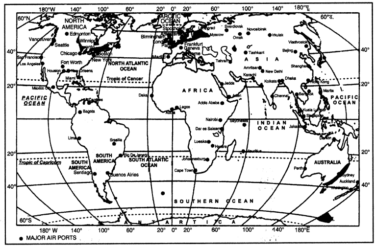
Nodal points. U.S.A. alone accounts for the 60% of this airways of the world. New York, London, Paris, Amestardam, Frankfurt, Rome, Moscow, Karachi, New Delhi, Mumbai, Bangkok, Singapore, Tokyo, San Francisco, Los Angeles and Chicago are nodal points where air routes coverage or radiate.
Question 4.
Answer:
Ocean routes are the most important and the cheapest means of transportation. It is the mainstay of international trade. When the ships regularly follow a well defined track, it is called a route.Importance of Ocean Routes :
- It is the cheapest means of transport.
- It is a natural highway and involves no expenditure on its construction.
- It is a global route as all the oceans are inter-linked.
- It saves a lot of coal and petroleum as fuel.
- It carries heavy goods. Cost of transportation becomes low.
Factors influencing the ocean routes. Ocean routes depend on the following factors:
- Ocean routes follow great circles (the shortest distance between two points on the globe).
- Ships pass through the points where cargo is available.
- Ships avoid areas of icebergs, fog and storms.
- Ships stop at ‘ports of call’ where fuel is available.
- Ocean routes pass through densely populated and economically developed areas.
Major Ocean Routes of the World. The major ocean routes are located in mid-latitude countries.
1. North Atlantic Route. This route lies between 40° – 50° N latitudes and connects Europe and North America. It is the busiest route of the world. About 25% ships of the world follow this route.
About half the major ports of the world are located on this route. This route connects the two continents highly developed in manufacturing, transportation and trade. This is called Big-Trunk Route.
This route follows the Great Circle. This route is well served with Coal and Petroleum. On both sides of the route, there are many deep, protected harbours and modern shipyards. The route connects two regions of dense population with a high standard of living of the people. The route suffers from the handicaps of fog and icebergs near Newfoundland.
Ports and Trade. The important ports of the European side of the route are London, Liverpool, Glasgow, Oslo, Hamburg, Rotterdam and Lisbon. On the American side of the route, the major ports are Quebec, Montreal, Halifax, Boston, Philadelphia and New York. This route handles about one fourth of the world’s trade.
The East-bound traffic consists of wheat, cotton, wood-pulp, petroleum, dairy products and fruits. The West-bound traffic consists of medicines, olives, chalk, pyrites and manufactured goods.
2. The Suez Route. This route runs through the heart of the old world. It serves most of the world-land area and most of the world’s population. It is known as Grand Trunk Route as regards its length. It is a vital link between the Northern and Southern continents.
This route is well served with coal and petroleum. This route has resulted in the saving of distance of 8000 kms. between Asia and Europe. The Suez route has been called the Life-Line of the British Empire.
Ports and Trade. This route extends from Western Europe through Mediterranean Sea upto Suez Canal. After crossing the Suez Canal it runs through Red Sea and Indian Ocean. This route follows three directions:
- Towards South-Africa.
- Towards Australia and New Zealand.
- To India and the Far-East.
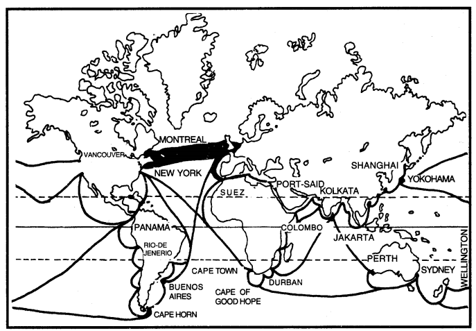
This route is a short-cut to Afro-Asian market. On the western side, European Ports serve this route. On the Eastern side, the important ports are Aden, Karachi, Mumbai, Kolkata, Chennai, Colombo, Rangoon, Singapore, Hongkong, Shanghai, Yokohama, Melbourne and Wellington. The
East-bound traffic consists of manufactured goods, machinery, chemicals, medicines. The West- bound traffic consists of oil, dates from the Persian Gulf; jute, tea, sugar from India; tin and rubber from Malaysia ; sugar, tea, spices from Indonesia; silk and cotton textiles from China and Japan, dairy products from Australia.
3. The Panama Route. This route connects the Atlantic Ocean and Pacific Ocean. The Panama canal was opened in 1914. The Panama Canal is the Gateway to the Pacific. This route has increased the trade between the West coasts of America and Europe. It has eliminated the long voyage round the stormy Cape Horn. It has reduced the distance between East and West of North America by 10,000 kms.
Ports and Trade. The important ports on the western side are Auckland, Valparaiso, Los Angeles, San Francisco, Vancouver and Prince Rupert. On the eastern coast, the important ports are Kingston, Havana, Rio-de- Janeiro, Panama and New Orleans. There is a great exchange of minerals and raw materials between these regions. Iron-ore, nitrates, copper, cotton, coffee move along this route in exchange for manufactured goods.
4. Cape of Good-Hope Route. The route was discovered in 1498 by Vasco-de-Gama. It became an important route due to the closure of Suez canal. It connects Europe with South-Africa, Australia and New Zealand. This route follows a great circle to clear the shoulder of Africa. This route is cheaper than Suez route. Cape of Good-Hope? is a focus of many trade routes from Europe to
- South Africa
- Persian-Gulf
- Far- East
- Australia and New Zealand.
Ports and Trade. On the western side, it serves all the important ports of Europe. On the eastern side, Capetown, Durban, Dar-es-Salaam, Adelaide, Sydney and Jakarta are the important ports. The East-bound traffic consists of manufactured goods, machinery, automobiles and medicines. Large quantities of wheat, hides, rubber, sugar, copper, gold, wool and coffee are exported to Europe.
5. Trans-Pacific Routes. This route connects the western coas t of North America with Asia. This is an unimportant route. Few ships move across the vast ocean. It forms a Great circle route. Several routes meet at Honolulu. It is called the cross roads of the Pacific.
Ports and Trade. The important ports on the American side are Vancouver, Prince Rupert, San Francisco and Los Angeles. On the eastern side, Yokohama, Hong Kong, Manila, Sydney and Auckland are important ports. Wood-pulp, wheat, paper and machinery is exported towards Asian side. Sugar, jute, tea, silk, toys, rubber, teak are sent to North America.
6. The South Atlantic Route. This route connects West Indies and South America with Europe. It links the agricultural nations of Brazil and Argentina with the industrial regions of Europe and U.S.A. Cape San Roque (Brazil) leads this route into two branches, one to Europe and the other-to North America.
Ports and Trade. On the northern side, it serves the ports of Europe and North America. On the southern side, the important ports are Kingston, Bahia, Santos, Buenos Aires, Monte Video and Rio-de-Janeiro. Wheat, coffee, sugar and wool are sent to Europe in exchange of coal, machinery and manufactured goods.
Question 5.
Answer:
Suez canal1. Location. The Suez Canal is the longest navigation canal in the world. It has been cut across the isthmus of Suez in Egypt.
2. History. The construction of Suez canal was begun by French Engineer, Ferdinand-de-Lesseps in 1859. It was opened on 17th November, 1869. It took ten years to complete this canal at a cost of Pound 180 lakh. The canal was nationalised on 26 July, 1956 by Col. Abdul Nasser to help-the construction of Aswan dam. Due to war, the canal remained closed till 1975 due to Arab-Israel conflict.
3. Seas and Ports. Suez canal joins the Red Sea with the Mediterranean. On the Mediterranean Sea, Port Said is the major Port while Port Suez stands on the Red Sea side. This canal is 162 kms. long, has a depth of 13 metres and a width of 60 to 80 metres. This is a sea-level canal passing through a level area. It has 3 salt lakes :
- Little Bitter Lake
- Great Bitter Lake
- Timshah Lake.
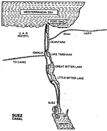
It takes about 12 hours to cross this canal. The Suez Canal can handle about 10 ships a day. It is difficult for modern ships to pass through this canal.
4. Importance. This route runs through the densely populated areas. It is well served with coal and oil. Many deep, protected harbours are found on this route. It is located at the cross-roads of the three continents. It has been called the life-line of the British Empire. Ships avoid long route via Cape of Good-Hope. The distance between Europe and Asia has been shortened by about 8000 kms. This manmade navigation canal serves as gate-way to India Ocean.
5. Drawbacks. It is a narrow canal. It is not very deep. Modern ships and oil tankers cannot pass through it. It takes longer time to cross the canal due to oneway traffic. The canal taxes are very high. Therefore, it is a costly route. It needs regular dredging due to the sand falling into the canal.
The closure of Suez canal had adverse effect on the economy of many countries. It caused an increase in the prices of oil and raw materials. The canal had been re-opened on June 5, 1975. It has definitely helped India to increase her exports. Suez Canal is being deepened and widened at a great cost, but it will not be the same old romantic Suez Canal.
Question 6.
Answer:
Panama canal1. Location. Panama Canal has been cut across Panama isthmus. The canal lies in Panama situated in Central America.
2. History. After the opening of Suez Canal, Ferdinand-de-Lesseps started the construction of Panama Canal in 1882. The project faced many handicaps and was abandoned. In 1914, U.S.A. completed the construction of Panama Canal. This canal is constructed, owned and controlled by U.S.A. The construction of Panama Canal was a great feat of engineering.
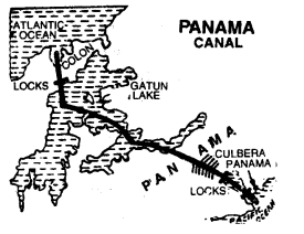
3. Ports and seas. The canal connects two great oceans—The Pacific and the Atlantic. It is also called the Gateway to the Pacific. The port of Colon is situated on the Atlantic while the port of Panama is situated on the Pacific. The canal is 81.6 km long, about 13 metres deep and the width varies from 90 to 305 metres. It takes ships about 8 hours to cross this canal.
The water level in the canal is 26 metres above sea level. So it is necessary to construct locks in the canal to raise and lower ships. The Panama Canal passes through:
(i) Two bays.
(ii) One artificial lake—Gatun lake
(iii) One natural lake
(iv) One cut through Culbera Ridge.
(v) Three lock systems
- Gatun locks
- Pedro Miquel lock
- Mira Flores lock.
4. Importance
(i) Panama Canal has changed the element of distance in geography of transportation. The Pacific Ocean and Atlantic Ocean are nearer to each other now by 1000 km.
(ii) It has eliminated the long voyage around the stormy Cape Horn.
(iii) It has reduced the distance between the eastern and western coasts of U.S.A.
(iv) Australia, New Zealand and South America are now nearer to Europe via Panama Canal.
(v) It is of great strategic importance to U.S.A. as she can keep only one navy.
5. Drawbacks:
(i) The system of locks is inconvenient, costly and delays the ships.
(ii) The vast Pacific Ocean has few ports and islands.
(iii) Large ships cannot pass through this canal.
(iv) The Panama Canal passes through thinly populated and under-developed countries.
Future. U.S.A is the biggest user of this canal. Almost 50 ships pass through this canal daily. The opening of this canal has helped the development of West India and Western coast of South America.
Question 7.
Answer:
Suez canal
1. Location. The Suez Canal is the longest navigation canal in the world. It has been cut across the isthmus of Suez in Egypt.
2. History. The construction of Suez canal was begun by French Engineer, Ferdinand-de-Lesseps in 1859. It was opened on 17th November, 1869. It took ten years to complete this canal at a cost of Pound 180 lakh. The canal was nationalised on 26 July, 1956 by Col. Abdul Nasser to help-the construction of Aswan dam. Due to war, the canal remained closed till 1975 due to Arab-Israel conflict.
3. Seas and Ports. Suez canal joins the Red Sea with the Mediterranean. On the Mediterranean Sea, Port Said is the major Port while Port Suez stands on the Red Sea side. This canal is 162 kms. long, has a depth of 13 metres and a width of 60 to 80 metres. This is a sea-level canal passing through a level area. It has 3 salt lakes :
- Little Bitter Lake
- Great Bitter Lake
- Timshah Lake.
It takes about 12 hours to cross this canal. The Suez Canal can handle about 10 ships a day. It is difficult for modern ships to pass through this canal.
4. Importance. This route runs through the densely populated areas. It is well served with coal and oil. Many deep, protected harbours are found on this route. It is located at the cross-roads of the three continents. It has been called the life-line of the British Empire. Ships avoid long route via Cape of Good-Hope. The distance between Europe and Asia has been shortened by about 8000 kms. This manmade navigation canal serves as gate-way to India Ocean.
5. Drawbacks. It is a narrow canal. It is not very deep. Modern ships and oil tankers cannot pass through it. It takes longer time to cross the canal due to oneway traffic. The canal taxes are very high. Therefore, it is a costly route. It needs regular dredging due to the sand falling into the canal.
The closure of Suez canal had adverse effect on the economy of many countries. It caused an increase in the prices of oil and raw materials. The canal had been re-opened on June 5, 1975. It has definitely helped India to increase her exports. Suez Canal is being deepened and widened at a great cost, but it will not be the same old romantic Suez Canal.
Panama canal
1. Location. Panama Canal has been cut across Panama isthmus. The canal lies in Panama situated in Central America.
2. History. After the opening of Suez Canal, Ferdinand-de-Lesseps started the construction of Panama Canal in 1882. The project faced many handicaps and was abandoned. In 1914, U.S.A. completed the construction of Panama Canal. This canal is constructed, owned and controlled by U.S.A. The construction of Panama Canal was a great feat of engineering.
3. Ports and seas. The canal connects two great oceans—The Pacific and the Atlantic. It is also called the Gateway to the Pacific. The port of Colon is situated on the Atlantic while the port of Panama is situated on the Pacific. The canal is 81.6 km long, about 13 metres deep and the width varies from 90 to 305 metres. It takes ships about 8 hours to cross this canal.
The water level in the canal is 26 metres above sea level. So it is necessary to construct locks in the canal to raise and lower ships. The Panama Canal passes through:
(i) Two bays.
(ii) One artificial lake—Gatun lake
(iii) One natural lake
(iv) One cut through Culbera Ridge.
(v) Three lock systems
- Gatun locks
- Pedro Miquel lock
- Mira Flores lock.
4. Importance
(i) Panama Canal has changed the element of distance in geography of transportation. The Pacific Ocean and Atlantic Ocean are nearer to each other now by 1000 km.
(ii) It has eliminated the long voyage around the stormy Cape Horn.
(iii) It has reduced the distance between the eastern and western coasts of U.S.A.
(iv) Australia, New Zealand and South America are now nearer to Europe via Panama Canal.
(v) It is of great strategic importance to U.S.A. as she can keep only one navy.
5. Drawbacks:
(i) The system of locks is inconvenient, costly and delays the ships.
(ii) The vast Pacific Ocean has few ports and islands.
(iii) Large ships cannot pass through this canal.
(iv) The Panama Canal passes through thinly populated and under-developed countries.
Future. U.S.A is the biggest user of this canal. Almost 50 ships pass through this canal daily. The opening of this canal has helped the development of West India and Western coast of South America.
Transport and Communication Important Extra Questions HOTS
Question 1.
Answer:
The river Rhine flows through Germany and Netherlands. It is the most used inland waterway.- It flows through a rich coalfield (Ruhr) and the whole basin is a prosperous manufacturing area.
- Huge tonnage vessels moved along the stretch, south of Ruhr each year more than 20,000 ocean going ships and 2,00,000 inland vessels exchange their cargo.
- It connects the industrial areas of Switzerland, Germany, France, Belgium and the Netherlands with the North Atlantic sea route.
Question 2.
(i) Identify and name the canal shown in the map.
Answer:
Panama canal(ii) Explain any two features of this canal.
Answer:
- The canal connects two great oceans-the Pacific and the Atlantic. It is also called the gateway to the Pacific.
- Panama canal has been cut across Panama Isthmus.
- It has reduced the distance between eastern and western coasts of U.S.A.
NCERT Class 12 Geography (Fundamentals of Human Geography)
Class 12 Geography Chapters | Geography Class 12 Chapter 8
Class 12 Geography NCERT Solutions: Fundamentals of Human Geography
NCERT Solutions for Class 12 Geography: Fundamentals of Human Geography
-
NCERT Solutions For Class 12 Geography Chapter 1 Human Geography (Nature and Scope)
NCERT Solutions For Class 12 Geography Chapter 2 The World Population (Distribution, Density and Growth)
NCERT Solutions For Class 12 Geography Chapter 3 Population Composition
NCERT Solutions For Class 12 Geography Chapter 4 Human Development
NCERT Solutions For Class 12 Geography Chapter 5 Primary Activities
NCERT Solutions For Class 12 Geography Chapter 6 Secondary Activities
NCERT Solutions For Class 12 Geography Chapter 7 Tertiary and Quaternary Activities
NCERT Solutions For Class 12 Geography Chapter 8 Transport and Communication
NCERT Solutions For Class 12 Geography Chapter 9 International Trade
NCERT Solutions For Class 12 Geography Chapter 10 Human Settlements
Class 12 Geography NCERT Solutions: India People and Economy
NCERT Solutions for Class 12 Geography: India People and Economy
-
NCERT Solutions For Class 12 Geography Chapter 1 Population: Distribution, Density, Growth and Composition
NCERT Solutions For Class 12 Geography Chapter 2 Migration: Types, Causes and Consequences
NCERT Solutions For Class 12 Geography Chapter 3 Human Development
NCERT Solutions For Class 12 Geography Chapter 4 Human Settlements
NCERT Solutions For Class 12 Geography Chapter 5 Land Resources and Agriculture
NCERT Solutions For Class 12 Geography Chapter 6 Water Resources
NCERT Solutions For Class 12 Geography Chapter 7 Mineral and Energy Resources
NCERT Solutions For Class 12 Geography Chapter 8 Manufacturing Industries
NCERT Solutions For Class 12 Geography Chapter 9 Planning and Sustainable Development in Indian Context
NCERT Solutions For Class 12 Geography Chapter 10 Transport And Communication
NCERT Solutions For Class 12 Geography Chapter 11 International Trade
NCERT Solutions For Class 12 Geography Chapter 12 Geographical Perspective on Selected Issues and Problems
Practical Work in Geography Class 12 Solutions
NCERT Solutions for Class 12 Geography: Practical Work in Geography
-
NCERT Solutions For Class 12 Geography Chapter 1 Data – Its Source and Compilation
NCERT Solutions For Class 12 Geography Chapter 2 Data Processing
NCERT Solutions For Class 12 Geography Chapter 3 Graphical Representation of Data
NCERT Solutions For Class 12 Geography Chapter 4 Use of Computer in Data Processing and Mapping
NCERT Solutions For Class 12 Geography Chapter 5 Field Surveys
NCERT Solutions For Class 12 Geography Chapter 6 Spatial Information Technology
Post a Comment
इस पेज / वेबसाइट की त्रुटियों / गलतियों को यहाँ दर्ज कीजिये
(Errors/mistakes on this page/website enter here)