
NCERT Solutions | Class 11 Geography (Fundamentals of Physical Geography) Chapter 10 | Atmospheric Circulation and Weather Systems

CBSE Solutions | Geography Class 11
Check the below NCERT Solutions for Class 11 Geography (Fundamentals of Physical Geography) Chapter 10 Atmospheric Circulation and Weather Systems Pdf free download. NCERT Solutions Class 11 Geography were prepared based on the latest exam pattern. We have Provided Atmospheric Circulation and Weather Systems Class 11 Geography NCERT Solutions to help students understand the concept very well.
NCERT | Class 11 Geography (Fundamentals of Physical Geography)
| Book: | National Council of Educational Research and Training (NCERT) |
|---|---|
| Board: | Central Board of Secondary Education (CBSE) |
| Class: | 11 |
| Subject: | Geography |
| Chapter: | 10 |
| Chapters Name: | Atmospheric Circulation and Weather Systems |
| Medium: | English |
Atmospheric Circulation and Weather Systems | Class 11 Geography | NCERT Books Solutions
Important Questions for Class 11 Geography Chapter 10 Atmospheric Circulation and Weather Systems
Atmospheric Circulation and Weather Systems Important Extra Questions Very Short Answer Type
Question 1.
Answer:
Atmospheric pressure is the weight of the column of air on the surface of the earth at sea level.Question 2.
Answer:
The atmospheric pressure at sea level is about 1 kilogram per cm2.Question 3.
Answer:
The amount of pressure exerted by air at a particular time is determined by temperature and density.Question 4.
Answer:
The air pressure is measured as a force per unit area. The units of measurements are millibar (Mb).Question 5.
Answer:
There exists an inverse relationship between pressure and temperature.Question 6.
Answer:
On its axis, the earth rotates from west to east.Question 7.
Answer:
There are seven pressure belts in all.Question 8.
Answer:
Between 45” North and Arctic Circle in the northern hemisphere, and 45° South and Antarctic Circle in the southern hemisphere.Question 9.
Answer:
The other names used for westerlies are ‘roaring forties’, ‘furious fifties’, and ‘striking sixties’.Question 10.
Answer:
The two places with the heaviest rainfall in India are Mawsinram and Cherrapunji.Question 11.
Answer:
The properties of air masses include their temperature, humidity, hydrostatic moisture content, stability, and abundance of minor content.Question 12.
Answer:
They are located over warmer high latitude oceans of North Pacific, North Atlantic Ocean, and entire sweep of southern hemisphere oceans, fringing Antarctica.Question 13.
Answer:
Inter-Tropical Convergence Zone.Question 14.
Answer:
It is a unit of measurement of atmospheric pressure.Question 15.
Answer:
The two types of pressure systems are high-pressure systems and low-pressure systems.Question 16.
Answer:
The pressure gradient is defined as the decrease in pressure per unit distance in the direction in which the pressure decreases most rapidly.Question 17.
Answer:
The isobars are imaginary lines drawn through places having equal atmospheric pressure at sea-level.Question 18.
Answer:
Because the air becomes thinner or its density decreases rapidly upwards from the surface of the earth.Question 19.
Answer:
These are local winds like land and sea breeze.Question 20.
Answer:
Barometer.Question 21.
Answer:
1013.25 Mb.Question 22.
Answer:
They control temperature and precipitation.Question 23.
Answer:
1 Mb for every ascent of 110 meters.Question 24.
Answer:
Chinook.Question 25.
Answer:
At poles and equator respectively.Question 26.
Answer:
Temperate and tropical cyclones.Question 27.
Answer:
Depressions and western disturbances.Atmospheric Circulation and Weather Systems Important Extra Questions Short Answer Type
Question 1.
Answer:
Air pressure and winds control temperature and precipitation. Even a minor change in pressure changes the velocity and direction of winds and this, in turn, brings about changes in temperature and precipitation.Question 2.
Answer:
On the rotating earth, a point on the equator moves the fastest. As we go towards the poles, the speed decreases, reaching about zero at the pole. It is because of this difference in speed that any moving body, such as winds and ocean currents, gets deflected when it moves towards the equator or away from the equator. This force or deflection is called Coriolis. It was discovered by Coriolis, a French mathematician.Question 3.
Answer:
Ferrel’s law states that all moving bodies like wind and ocean currents get deflected from their normal paths towards the right in the northern hemisphere and towards the left in the southern hemisphere. The role of deflection increases with the distance from the equator. As a result, by the time the poleward directed winds reach 25 degrees latitude, they are deflected into nearly west to east flow.Question 4.
Answer:
The ITCZ means Inter-Tropical Convergence Zone. It is also known as Inter-Tropical Front (ITF). It is an equatorial front. It is a broad trough of low pressure defined more sharply over land than over the ocean. The tropical maritime air masses converge here. In ITCZ, the north-east trade winds and the south-east trade winds meet. This zone is mainly stationed over the equator but moves north and south according to the season. The air mass may be almost stagnant, the winds light and variable. Hence the air belt is calm, known as doldrums.Question 5.
Answer:
The pressure gradient is the rate at which pressure rises or falls. The gradient is steep when pressure changes in a short distance and mild when pressure changes at long distances. The pressure gradient is shown by isobars. When isobars are closer, the pressure gradient is steep and vice-versa.Question 6.
Answer:
These winds are generated by the influence of the surrounding terrain. They include mountain and valley winds, land and sea-breezes, and other local winds such as loo, foehn, chinook and mistral, etc. Some winds are hot and some winds are cold winds. All are local winds.Question 7.
Answer:
The southern hemisphere has mostly sea and very little land. Westerlies, therefore, blow without any hindrance and with great velocity. Their roar can be heard far and wide. The westerlies here are called roaring forties.Question 8.
Answer:
The pressure and temperature have an inverse relationship with each other. As the air gets heated, it expands and rises upwards. The higher the temperature, the lower is the pressure. On the other hand, cold air contracts and becomes heavy. It results in high pressure.Question 9.
Answer:
The latitudes near the tropics are known as horse latitudes. In this zone, no permanent winds blow. It is a region of high pressure due to descending winds.The sailing ships from Europe to America had to face problems due to the absence of backing winds. Therefore, some horses were thrown into the sea to make their ships lighter and to move further. This is why these latitudes are known as horse latitudes.
Question 10.
Answer:
The winds with a high velocity which blow at high altitude are called the jet stream. This strong current of air is located near 90° north latitude. It affects the weather patterns of the world. High flying planes use these as super tailwinds to save time and fuel.Question 11.
Answer:
Winds having special characteristics under local conditions are known as local winds.- Hot winds: Chinook in Canada and USA, foehn in Switzerland.
- Dry winds: Sirocco in south Europe, Khanzim in Egypt, Hermatton in West Africa, Simoon of Arabia, Santa Anna of California, Zenda of Argentina.
- Cold winds: Boro and Mistral in Southern Europe, Pampero in Argentina, Buran in Siberia.
Question 12.
Answer:
The doldrum is an equatorial low-pressure belt between 5°N to 5°S latitudes. It is known as the-belt of calm. The air is constantly heated due to the high temperature. The air expands and rises as convection currents. There are no surface winds. Sailing ships often found them becalmed in this belt due to the absence of backing winds.Question 13.
Answer:
Air mass is important for climatological study. Air masses are related to atmospheric disturbances, cyclones, storms, and fronts.- The distribution and location of air provide an essential understanding of regional climate.
- Air masses transfer heat from lower latitude to higher latitudes.
- Atmosphericdisturbancesdevelopalongfrontsofdifferentairmasses.
- Air masses are associated with particular types of wind belts and determine the weather characteristics.
Question 14.
Answer:
The valley breeze occurs during day time. Due to insolation, the valley bottom gets heated. The hot air becomes light and ascends towards the upper slopes. It is known as the valley breeze.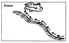
Fig. 10.3: Slopes heated by insolation
Atmospheric Circulation and Weather Systems Important Extra Questions Long Answer Type
Question 1.
1. planetary and periodic winds,
2. the sea breeze and land breeze.
Answer:
1. Planetary and periodic winds:Planetary winds are related to the general circulatory pattern of winds on the rotating earth’s surface. These winds constitute the large-scale motion of the atmosphere under the influence of pressure gradients. They ignore seasonal heating and land-water contrast on the earth’s surface. They are also called permanent or primary wind system of the earth’s surface and comprise trade winds, westerlies, and polar easterlies. These winds blow constantly in a particular direction throughout the year.
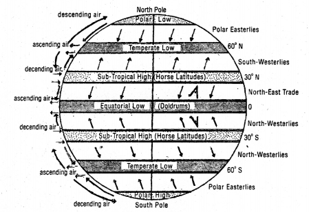
Fig. 10.4: Planetary winds
The winds that change their direction periodically with the change in season are called periodic or secondary winds. Monsoon, air masses and fronts, cyclones and anticyclones, land and sea breezes, and mountain and valley breezes are the wind systems that periodically change their courses diurnally or seasonally.
2. Land and sea breezes:
Daily temperature contacts between land and water produce a small diurnal reversal of winds called land and sea breezes. Both are basically caused by differential heating of land and sea.
During the day, the land gets heated up much faster than the sea. The sea remains comparatively cool with higher pressure, so the sea breeze blows in from the sea to land during the day. Its speed is between 5-20 miles/hour and it is generally stronger in tropical than temperate regions.
Its influence does not normally exceed 15 miles from the coast. It is most deeply felt when one stands facing the sea in a coastal area.
At night, the reverse takes place. As the land cools down much faster than the sea, the cold and heavy air produces a region of local high pressure. The sea conserves its heat and remains quite warm. Its pressure is comparatively low. A land breeze thus blows out from land to sea.
Fishermen in the tropics often take advantage of the outgoing land breeze and sail out with it.
Question 2.
Answer:
The horizontal distribution of pressure, or its global pattern in general, presents an alternate belt of low and high-pressure areas.There is an inverse relationship between pressure and temperature. The equatorial region having high temperature has low pressure, while the polar regions with low temperature have high pressure. These pressure belts are thermally induced. Logically, there should have been a gradual increase in pressure from the equator towards the poles.
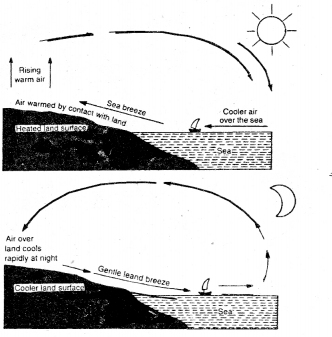
Fig. Pressure belts of the world (See fig.9.1)
There are two intermediate zones of subtropical highs in the vicinity of 30°N and S and two sub-polar lows in the vicinity of 60°N and S. The dynamic control, viz., pressure gradient force, rotation of the earth, are responsible for the formation of these pressure belts.
Thus there are seven pressure belts:
- An equatorial trough of low pressure.
- Sub-tropical high-pressure belt (Northern hemisphere)
- Sub-polar low-pressure belt (Northern hemisphere)
- Sub-polar low-pressure belt (Southern hemisphere)
- Sub-tropical high-pressure belt (Southern hemisphere)
- Polar high (Northern hemisphere)
- Polar high (Southern hemisphere)
Question 3.
Answer:
Despite a broad generalized pattern of pressure distribution on the earth, pressure conditions vary considerably on the basis of prevailing weather conditions in different parts of the world. The horizontal distribution of pressure on the earth’s surface is shown by isobar. Just as there is a daily range of temperature on the surface of tire earth, so there is the diurnal rhythm of pressure.The direction and rate of change in pressure are called pressure gradient. It is at right angles to isobars, just as the slope of the land surface is at right angles to contour, lines. The rate of change or steepness of the gradient is shown by the spacing of isobars. Closely spacing isobars show’ steep pressure gradient, and widely spaced isobars show’ gentle gradient.
The zonal distribution of pressure is modified by continents and oceans, in summer, the relatively hot continents intensify the low-pressure cells and weaken or destroy high-pressure cells. In a similar manner, the corresponding cooler oceans weaken the low-pressure cells and the high-pressure cells. In winter the situation is reversed. ,

Fig. 10.6: Horizontal distribution of pressure and winds
Question 4.
Answer:
Cyclones constitute the most fundamental and climatically the most significant atmospheric disturbances affecting the weather. On the basis of the areas of their origin, they are classified into two types: temperate and tropical.Temperate cyclones: Temperate1 cyclones are concentrated in the middle latitudes between 35° and 65° in both hemispheres. They are generally extensive having a vertical thickness ranging from 9 to 11 km. and a diameter of about 1,000 km. It is just like a spearhead, having the shape of an upturned ‘V’. The approaching temperate cyclones are noticed by the appearance of dark clouds in the background of white clouds.
According to polar front theory, the highs and lows of westerly wind belts result from the interactions and alteration of two contrasting types of air masses, one in the polar region and the other in the subtropics. Cold air from highs moves toward the equator and is deflected westward, forming the northeast and southeast polar winds. Warmer air from the subtropical highs moves toward the poles and by an eastward deflection from the westerly winds.
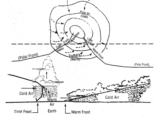
Fig. 10.7: Temperate cyclones
As soon as the cyclone approaches, there is drizzle followed by heavy rainfall. The velocity of the wind increases. On the approach of the warm front, the fall in the pressure stops, and the sky becomes clear. This gives the clue that the center of the cyclones has reached. Immediately after this, the temperature begins to fall and the sky becomes cloudy and raining again. This indicates the approach of a cold front.
Tropical cyclones: These are violent storms that originate over tropical seas and move over the coastal areas bringing about large-scale destruction caused by violent winds, very heavy rainfall, and storm surges. They are known as cyclones in the Indian ocean, hurricanes in the Atlantic, typhoons in the western Pacific and South China sea, and willy-willies in west Australia. The conditions favorable for the formation and intensification of tropical storms are:
- Large sea surface with a temperature higher than 27°C.
- Presence of the Coriolis force.
- Small variations in the vertical wind speed.
- A pre-existing weak low-pressure area or low level cyclonic
circulation. - Upper divergence above the sea level system.
The cyclone creates stone surges and they inundate the coastland. Over the Indian sea, the cyclonic storms occur in the pre-monsoon
Question 5.
Answer:
The contact line between air masses of different properties is called a front. A cold front develops where the cold air mass moves under warm air mass and lifts it up. On the other hand, the trailing edge of a cold air mass that is followed by warm air is called a warm front. In each case, precipitation is likely to occur because warm air is rising over the cold air. Thus duration and intensity of precipitation along the few from.s are quite different. The cold front is steep and produces showery and sometimes violet precipitation for a longer period of time. If the cold front moves faster than the warm front in such a trap, part or all the pocket of warm air may be lifted from the surface, thus producing air occluded front. Often exculpation of the air masses lose earlier characters and form new fronts.NCERT Class 11 Geography (Fundamentals of Physical Geography)
Class 11 Geography Chapters | Geography Class 11 Chapter 10
NCERT Class 11 Fundamentals of Physical Geography Solutions
NCERT Solutions for Class 11 Geography: Fundamentals of Physical Geography
-
NCERT Solutions For Class 11 Geography Chapter 1 Geography as a Discipline
NCERT Solutions For Class 11 Geography Chapter 2 The Origin and Evolution of the Earth
NCERT Solutions For Class 11 Geography Chapter 3 Interior of the Earth
NCERT Solutions For Class 11 Geography Chapter 4 Distribution of Oceans and Continents
NCERT Solutions For Class 11 Geography Chapter 5 Minerals and Rocks
NCERT Solutions For Class 11 Geography Chapter 6 Geomorphic Processes
NCERT Solutions For Class 11 Geography Chapter 7 Landforms and their Evolution
NCERT Solutions For Class 11 Geography Chapter 8 Composition and Structure of Atmosphere
NCERT Solutions For Class 11 Geography Chapter 9 Solar Radiation, Heat Balance and Temperature
NCERT Solutions For Class 11 Geography Chapter 10 Atmospheric Circulation and Weather Systems
NCERT Solutions For Class 11 Geography Chapter 11 Water in the Atmosphere
NCERT Solutions For Class 11 Geography Chapter 12 World Climate and Climate Change
NCERT Solutions For Class 11 Geography Chapter 13 Water (Oceans)
NCERT Solutions For Class 11 Geography Chapter 14 Movements of Ocean Water
NCERT Solutions For Class 11 Geography Chapter 15 Life on the Earth
NCERT Solutions For Class 11 Geography Chapter 16 Biodiversity and Conversation
NCERT Class 11 India Physical Environment Solutions
NCERT Solutions for Class 11 Geography: India Physical Environment
-
NCERT Solutions For Class 11 Geography Chapter 1 India: Location
NCERT Solutions For Class 11 Geography Chapter 2 Structure and Physiography
NCERT Solutions For Class 11 Geography Chapter 3 Drainage System
NCERT Solutions For Class 11 Geography Chapter 4 Climate
NCERT Solutions For Class 11 Geography Chapter 5 Natural Vegetation
NCERT Solutions For Class 11 Geography Chapter 6 Soils
NCERT Solutions For Class 11 Geography Chapter 7 Natural Hazards and Disasters
Practical Work in Geography Class 11 Solutions
NCERT Solutions for Class 11 Geography: Practical Work in Geography
-
NCERT Solutions For Class 11 Geography Chapter 1 Introduction to Maps
NCERT Solutions For Class 11 Geography Chapter 2 Map Scale
NCERT Solutions For Class 11 Geography Chapter 3 Latitude, Longitude and Time
NCERT Solutions For Class 11 Geography Chapter 4 Map Projections
NCERT Solutions For Class 11 Geography Chapter 5 Topographical Maps
NCERT Solutions For Class 11 Geography Chapter 6 Introduction to Aerial Photographs
NCERT Solutions For Class 11 Geography Chapter 7 Introduction to Remote Sensing
NCERT Solutions For Class 11 Geography Chapter 8 Weather Instruments, Maps and Charts
Post a Comment
इस पेज / वेबसाइट की त्रुटियों / गलतियों को यहाँ दर्ज कीजिये
(Errors/mistakes on this page/website enter here)