
NCERT Solutions | Class 11 Geography (Practical Work in Geography) Chapter 6 | Introduction to Aerial Photographs

CBSE Solutions | Geography Class 11
Check the below NCERT Solutions for Class 11 Geography (Practical Work in Geography) Chapter 6 Introduction to Aerial Photographs Pdf free download. NCERT Solutions Class 11 Geography were prepared based on the latest exam pattern. We have Provided Introduction to Aerial Photographs Class 11 Geography NCERT Solutions to help students understand the concept very well.
NCERT | Class 11 Geography (Practical Work in Geography)
| Book: | National Council of Educational Research and Training (NCERT) |
|---|---|
| Board: | Central Board of Secondary Education (CBSE) |
| Class: | 11 |
| Subject: | Geography |
| Chapter: | 6 |
| Chapters Name: | Introduction to Aerial Photographs |
| Medium: | English |
Introduction to Aerial Photographs | Class 11 Geography | NCERT Books Solutions
Practical Work in Geography Class 11 Solutions Chapter 6 Introduction to Aerial Photographs
Class 11 Practical Work in Geography Chapter 6 NCERT Textbook Questions Solved
1. Multiple choice questions.
Question 1(i).
(a) Vertical
(b) Near-vertical
(c) Low-oblique
(d) High-oblique.
Answer:
(c) Low-obliqueQuestion 1(ii).
(a) Vertical
(b) Near-vertical
(c) Low-oblique
(d) High-oblique.
Answer:
(d) High-oblique.Question 1(iii).
(a) Parallel
(b) Orthogonal
(c) Central
(d) None of the above.
Answer:
(c) Central.2. Answer the following questions in about 30 words.
Question 2(i).
Answer:
The photographs taken from ground provide us with a view of the object similar to the way we see them with our own eyes. In other words, we get a horizontal perspective of the objects photographed. The basic advantages that aerial photographs offer over ground based observation are:1. Improved vantage point and Time freezing ability: Aerial photography provides a bird’s eye view of large areas, enabling us to see features of the earth surface in their spatial context. An aerial photograph is a record of the surface features at an instance of exposure. Therefore, it can be used as a historical record.
2. Broadened Sensitivity: The sensitivity of the film used in taking aerial photographs is relatively more than the sensitivity of the human eyes. Our eyes perceive only in the visible region of the electromagnetic spectrum, i.e. 0.4 to 0.7 pm whereas the sensitivity of the film ranges from 0.3 to 0.9 pm.
3. Three Dimensional Perspective: Aerial photographs are generally taken with uniform exposure interval. It enables us in obtaining stereo pair of photographs. Such a pair of photographs helps us in getting a three-dimensional view of the surface photographed.
Question 2(ii).
Answer:
Aerial photographs are taken from the camera kept in aeroplane or helicopter. These are taken from aerial camera which is a precision camera specifically designed for use in aircrafts. It makes use of Aerial Film which is a roll film with high sensitivity, high intrinsic resolution power and dimensionally stable emulsion support. Therefore we can say that aerial photography is an art, science and technology of taking aerial photographs from an air-bome platform.Question 2(iii).
Answer:
Aerial photography in India was taken for the first time in1920 when large-scale aerial photographs of Agra city were obtained.Subsequently, Air Survey Party of the Survey of India took up aerial survey of Irrawaddy Delta forests, which was completed during 1923-24. Subsequently, several similar surveys were carried out and advanced methods of mapping from aerial photographs were used.
Today, aerial photography in India is carried out for the entire country under the overall supervision of the Directorate of Air Survey (Survey of India) New Delhi. Three flying agencies, i.e. Indian Air Force; Air Survey Company, Kolkata and National Remote Sensing Agency, Hyderabad have been officially authorised to take aerial photographs in India.
3. Answer the following questions in about 125 words.
Question 3(i).
Answer:
Aerial photographs are used in topographical mapping and interpretation. These two different uses have led to the development of photogrammetry and photo/image interpretation as two independent but related sciences.1. Photogrammetry refers to the science and technology of making reliable measurements from aerial photographs. The principles used in photogrammetry facilitate precise measurements related to the length, breadth and height from such photographs. Hence, they are used as the data source for creating and updating topographic maps.
2. Image Interpretation is an art of identifying images of objects and judging their relative significance. The principles of image interpretation are applied to obtain qualitative information from the aerial photographs such as land use/land cover, topographical forms, soil types, etc. A trained interpreter can thus utilise aerial photographs to analyse the land- use changes.
Question 3(ii).
Answer:
Scale is the ratio of a distance on an aerial photograph the distance between the same two places on the ground in the real world. It can be expressed in unit equivalents like 1 cm = 1,000 km(or 12,000 inches) or as a representative fraction (1:100,000). Scale determines what objects would be visible, the accuracy of estimates and how certain features will appear.There are three methods to compute the scale of an aerial photograph using different sets of information.
Method 1:
By Establishing Relationship Between Photo Distance and Ground Distance: If additional information like ground distances of two identifiable points in an aerial photograph is available, it is fairly simple to work out the scale of a vertical photograph. The corresponding ground distances is expressed by Dg and for which the distances on an aerial photograph is expressed as Dp. Both are measured. In such cases, the scale of an aerial photograph will be measured as a ratio of the two, i.e.Dp /Dg.
Method 2:
By Establishing Relationship Between Photo Distance and Map Distance: The distances between different points on the ground are not always known. However, if a reliable map is available for the area shown on an aerial photograph, it can be used to determine the photo scale. In other words, the distances between two points identifiable both on a map and the aerial photograph enable us to compute the scale of the aerial photograph (Sp).
The relationship between the two distances may be expressed as under: (Photo scale: Map scale) = (Photo distance: Map distance) We can derive Photo scale (Sp) = Photo distance (Dp): Map distance (Dm) x Map scale factor (msf)
Method 3:
By Establishing Relationship Between Focal Length (f) and Flying Height (H) of the Aircraft:
If no additional information is available about the relative distances on photograph and ground/map, we can determine the photo scale provided the information about the focal length of the camera (f) and the flying height of the aircraft (H) are known. The photo scale so determined could be more reliable if the given aerial photograph is truly vertical or near vertical and the terrain photographed is flat. The focal length of the camera (f) and the flying height of the aircraft (H) are provided as marginal information on most of the vertical photographs. Aerial photograph may be used to derive the photo-scale formula in the following way: Focal Length (f): Flying Height (H) = Photo distance (Dp):
Ground distance (Dg)
Class 11 Practical Work in Geography Chapter 6 NCERT Extra Questions
Class 11 Practical Work in Geography Chapter 6 Multiple Choice Questions
Question 1.
(a) Vertical photographs
(b) Low oblique photographs
(c) High oblique photographs
(d) Oblique photographs
Answer:
(d) Oblique photographsQuestion 2.
(a) Gaya (1905)
(b) Varanasi (1910)
(c) Agra (1920)
(d) Lucknow (1930)
Answer:
(c) Agra (1920)Question 3.
(a) France (1909)
(b) Germany (1910)
(c) Australia (1922)
(d) USA (1858)
Answer:
(a) France (1909)Question 4.
(a) Orthophoto
(b) Aerospace
(c) Focal length
(d) Flying image
Answer:
(c) Focal lengthQuestion 5.
(a) Scale
(b) Vertical length
(c) Focal length
(d) Axis
Answer:
(a) ScaleQuestion 6.
(a) Principal point .
(b) Principal distance
(c) Oblique
(d) Vertical length.
Answer:
(b) Principal distance.Class 11 Practical Work in Geography Chapter 6 Very Short Answer Type Questions
Question 1.
Answer:
A photograph taken from an air-borne platform using a precision camera is called an aerial photograph.Question 2.
Answer:
Aerial photographs are taken from the camera kept in helicopter or aeroplanes. On the other hand, satellite images are taken from man-made satellites launched in the space.Question 3.
Answer:
Eight important elements which are being used for describing satellite images are element size, shape, shadow, colour coordination, colour formation, background, correlation and context.Question 4.
Answer:
An image taken from man-made satellites launched in the space is called satellite image.Question 5.
Answer:
The photographs with the scale being smaller than 1 : 30,000, are referred to as small scale photographsQuestion 6.
Answer:
Index marks, rigidly connected at the central or corner edges of the camera body are called fudicial marks. When the film is exposed, these marks appear on the film negative.Question 7.
Answer:
Aerial photographs need to be transformed from perspective view to the planimetric view before they can be used as map substitute. Such transformed photographs are known as orthophotos.Question 8.
Answer:
The aerial photographs are classified on the basis of the position of the camera axis, scale, angular extent of coverage and the film used.Question 9.
Answer:
An aerial photograph is a record of the surface features at an instance of exposure. It can, therefore, be used as a historical record.Question 10.
Answer:
Aerial photograph may be used to derive the photo-scale formula in the following way:Focal Length (f): Flying Height (H) = Photo distance (Dp): Ground distance (Dg)
Question 11.
Answer:
This is a special case of parallel projections. Maps are orthogonal projections of the ground.Class 11 Practical Work in Geography Chapter 6 Short Answer Type Questions
Question 1.
Answer:
Given below are the advantages of aerial photographs:- The photographs taken from ground provide us with a view of the object similar to the way we see them with our own eyes. In other words, we get a horizontal perspective of the objects photographed. Aerial photography provides a bird’s eye view of large areas, enabling us to see features of the earth surface in their spatial context.
- An aerial photograph is a record of the surface features at an instance of exposure. Therefore, it can be used as a historical record.
- The sensitivity of the film used in taking aerial photographs is relatively more than the sensitivity of the human eyes. Our eyes perceive only in the visible region of the electromagnetic spectrum, i. e. 0.4 to 0.7 pm whereas the sensitivity of the film ranges from 0.3 to 0.9 pm.
- Aerial photographs are generally taken with uniform exposure interval. It enables us in obtaining stereo pair of photographs.
- Such a pair of photographs also helps us in getting a three-dimensional view of the surface photographed.
Question 2.
Answer:
Sp = Dp : Dg= 2 cm :1 km
= 2cm : 1 x 100,000 cm
= 1 : 100,000/2 = 50,000 cm
= 1 unit represents 50,000 units
Therefore, Sp = 1: 50,000.
Question 3.
Answer:
Photo scale (Sp) = Photo distance (Dp) : Map distance (Dm) x Map scale factor (msf)= 10 cm : 2 cm x 50,000
= 10 cm : 100,000 cm
= 1 : 100,000/10 = 10,000 cm
= 1 unit represents 10,000 units
Therefore, Sp = 1: 10,000
Question 4.
Answer:
Focal Length (f) : Flying Height (H) = Photo distance (Dp) : Ground distance (Dg)Sp = f: H
Or Sp = 15 cm : 7,500 x 100 cm
Or Sp = 1 : 750,000/15
Therefore, Sp = 1 : 50,000
Question 5.
(i) Aerial photograph and map.
(it) Aerial photographs and satellite images.
(iii) High oblique photograph and low oblique photograph.
(iv) Vertical photograph and high oblique photograph.
(v) Vertical photograph and low oblique photograph.
Answer:
(i)| Basis | Aerial Photograph | Map |
| Projection | It is a central Projection. | It is an orthogonal Projection. |
| Accuracy | An aerial photograph is geometrically incorrect. The distortion in the geometry is minimum at the centre and increases towards the edges of the photographs. | A map is geometrically correct representation of the part of the earth projected. |
| Scale | The scale of the photograph is not uniform. | The scale of the map is uniform throughout the map extent. |
| Impact of enlargement or reduction | Enlargement/reduction does not change the contents of the photographs and can easily be carried out. | Enlargement/reduction of the maps involves redrawing it afresh. |
| Utility | Aerial photography holds good for inaccessible and inhospitable areas. | The mapping of inaccessible and inhospitable areas is very difficult and sometimes it becomes impossible. |
(ii)
| Basis | Aerial Photographs | Satellite Images |
| Meaning | These are taken from an aeroplane or helicopter. | These are taken from man-made satellite launched in space. |
| Accuracy | These are less accurate as compared to satellite images. | These are more accurate as compared to aerial images. |
| Suitability | These are suitable for taking photographs of the earth. | These are used for taking photographs of other planets and celestial bodies. |
| Utility | Aerial photography holds good for inaccessible and inhospitable areas of the earth | It is useful in knowing climatic condition and weather forecast. |
| Disaster
management |
It is more useful in disaster management for providing relief. | It is more useful in disaster management by predicting weather and taking preventive actions. |
(iii)
| Basis | High Oblique Photograph | Low Oblique Photograph |
| Optical Axis | Deviation is more than 300 degree from the vertical axis. | Deviation is more than 30 degree from the vertical axis. |
| Coverage | It covers largest area. | It covers larger area. |
| Difference in comparison to map | It is greatest with high oblique photographs. | It is greater with low oblique photographs. |
| Utility | It is useful in illustrative comparison. | It is useful in recoqnaissance survey. |
(iv)
| Basis | Vertical Photograph | High Oblique Photograph |
| Optical Axis | Tilt< 3 degree i.e. exactly or nearly coincides with the vertical axis. | Deviation is more than 300 degree from the vertical axis. |
| Horizon | Horizon does not appear | Horizon does appear |
| Coverage | It covers small area. | It covers largest area. |
| Scale | Scale is uniform if the terrain is flat. | Scale keeps decreasing from foreground to background. |
| Difference in comparison to map | It is least with vertical photographs. | It is greatest with high oblique photographs. |
| Utility | It is useful in topographical and thematic mapping. | It is useful in illustrative comparison. |
(v)
| Basis | Vertical Photograph | Low Oblique Photograph |
| Optical Axis | Tilt< 3 degree i.e. exactly or nearly coincides with the vertical axis. | Deviation is more than 30 degree from the vertical axis. |
| Horizon | Horizon does not appear | Horizon does appear |
| Coverage | It covers small area. | It covers comparatively larger area. |
| Scale | Scale is uniform if the terrain is flat. | Scale keeps decreasing from foreground to background. |
| Difference in comparison to map | It is least with vertical photographs. | It is relatively greater with low oblique photographs. |
| Utility | It is useful in topographical and thematic mapping. | It is useful in reconnaissance survey. |
Class 11 Practical Work in Geography Chapter 6 Long Answer Type Questions
Question 1.
Answer:
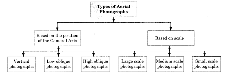
Types of Aerial Photographs Based onthe Position of the Cameral Axis:
1. Vertical Photographs: While taking aerial photographs, two distinct axes are formed from the camera lens centre, one towards the ground plane and the other towards the photo plane. The perpendicular dropped from the camera lens centre to the ground plane is termed as the vertical axis, whereas the plumb line drawn from the lens centre to the photo plane is known as the photographic/optical axis. When the photo plane is kept parallel to the ground plane, the two axes also coincide with each other. The photograph so obtained is known as vertical aerial photograph

2. Low Oblique: An aerial photograph
taken with an intentional deviation of 15° to 30° in the camera axis from the vertical axis is referred to as the low oblique photograph. This kind of photograph is often used in reconnaissance surveys. It is shown with the help of following figure.

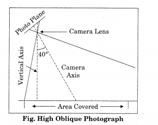
3. High Oblique: The high oblique are photographs obtained when the camera axis is intentionally inclined about 60° from the vertical axis. Such photography is useful in illustrative surveys. It is shown with the help of following figure.
Question 2.
Answer:
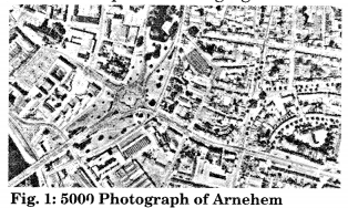
There are three types of Aerial Photographs Based on Scale.- Large Scale Photographs: When the scale of an aerial photograph is 1:15,000 and larger, the photography is classified as large-scale photograph. It is shown with the help of following figure.
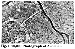
- Medium Scale Photographs: The aerial photographs with a scale ranging between 1 : 15,000 and 1 : 30,000 are usually treated as medium scale photographs as shown in the figure given below:
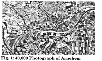
- Small Scale Photographs: The
photographs with the scale being smaller than 1 : 30,000, are referred to as small scale photographs as shown in the figure.
Question 3.
Answer:
These days, it has become very easy to draw’ maps and interpret them through aerial photographs and satellite images. It requires a special type of training to understand and interpret aerial photographs. Many countries are making use of aerial photographs not only for defence purposes but also for planning land use, development of cities and towns, development of multipurpose projects etc.Satellite images are used to predict climatic conditions. It becomes easy to predict weather by using satellite images, wre can find mineral availability, land use plan by making use of satellite images.
Question 4.
Answer:
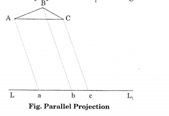
There are three types of projection:1. Parallel Projection: In this projection, the projecting rays are parallel but not necessarily perpendicular. The triangle ABC is projected on LL1 as triangle abc.
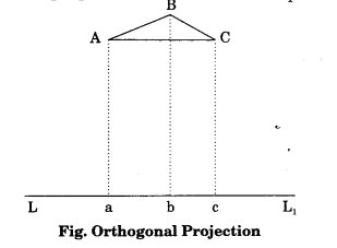
2. Orthogonal Projection: This is a special case of parallel projections. Maps are orthogonal projections of the ground. The advantage of this projection is that the distances, angles or areas on the plane are independent of the elevation differences of the objects. In the figure given below an orthogonal projection is where the projecting rays are perpendicular to the line LL1
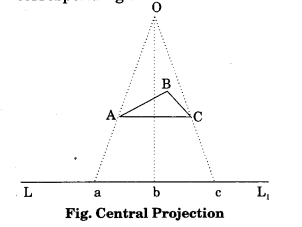
3. Central Projection: Figure given below shows an example of Central Projection. In this figure the projecting rays Aa, Bb and Cc pass through a common point O, which is called the perspective Centre. The image projected by a lens is treated like a central projection. An aerial photograph, as discussed earlier is a central projection. In an absolutely vertical flat terrain the aerial photograph will be geometrically the same as the corresponding map of the area. However, because of the tilt of the photograph and relief variations of the ground photographed, an aerial photograph differs geometrically from the map of the corresponding area.
Class 11 Practical Work in Geography Chapter 6 Viva Questions
Question 1.
Answer:
In India three flying agencies are officially permitted to carry out aerial photography. They are:- Indian Air Force,
- Air Survey Company, Kolkata and
- National Remote Sensing Agency, Hyderabad.
These are identified on the aerial photographs as A, B and C respectively.
Question 2.
Answer:
Aerial photograph may be used to derive the photo-scale formula in the following way:Focal Length (f): Flying Height (H) = Photo distance (Dp): Ground distance (Dg).
Question 3.
Answer:
If additional information like ground distances of two identifiable points in an aerial photograph is available, the corresponding ground distances is expressed by Dg and for which the distances on an aerial photograph is expressed as Dp. Both are measured. In such cases, the scale of an aerial photograph will be measured as a ratio of the two, i.e. Dp/ Dg.Question 4.
Answer:
The distances between different points on the ground are not always known. However, if a reliable map is available for the area shown on an aerial photograph, it can be used to determine the photo scale. In other words, the distances between two points identifiable both on a map and the aerial photograph enable us to compute the scale of the aerial photograph (Sp).The relationship between the two distances may be expressed as under: (Photo scale: Map scale) = (Photo distance : Map distance) We can derive Photo scale (Sp) = Photo distance (Dp): Map distance (Dm) x Map scale factor (msf).
Question 5.
Answer:
It will be called Medium Scale Photograph.Question 6.
Answer:
It will be called high oblique photograph.Question 7.
Answer:
Our eyes perceive only in the visible region of the electromagnetic spectrum, i. e. 0.4 to 0.7 pm whereas the sensitivity of the film ranges from 0.3 to 0.9 pm.Introduction to Aerial Photographs Notes
- First aerial photograph was taken in France in 1858 through a balloon. But in 1909, first time aeroplane was used to take aerial photographs when a photo for a city of Italy was taken. Aerial photographs were used at a large scale during both world wars.
- Aerial photography in India was taken for the first time inl920 when large-scale aerial photographs of Agra city were obtained. Subsequently, Air Survey Party of the Survey of India took up aerial survey of Irrawaddy Delta forests, which was completed during 1923-24.
- Today, aerial photography in India is carried out for the entire country under the overall supervision of the Directorate of Air Survey (Survey of India) New Delhi. Three flying agencies, i.e. Indian Air Force; Air Survey Company, Kolkata and National Remote Sensing Agency, Hyderabad have been officially authorised to take aerial photographs in India.
- The procedure for indenting aerial photographs for educational purposes could be made with APFPS Party No. 73, Directorate of Air Survey, Survey of India, West Block IV, R. K. Puram, New Delhi.
- Aerial photographs are used in topographical mapping and interpretation. These two different uses have led to the development of photogrammetry and photo/image interpretation as two independent but related sciences.
- Photogrammetry is the science and technology of making reliable measurements from aerial photographs. The principles used in photogrammetry facilitate precise measurements.
- The aerial photographs are classified on the basis of the position of the camera axis, scale, angular extent of coverage and the film used.
- On the basis of the position of the camera axis, aerial photographs are classified into the following types : (i) Vertical photographs
- Low oblique photographs
- High oblique photographs
- On the basis of scale, aerial photographs are of three types: large scale photographs, medium scale photographs and small scale photographs.
- While taking aerial photographs, two distinct axes are formed from the camera lens centre, one towards the ground plane and the other towards the photo plane.
- To understand the geometry of an aerial photograph, it is important to appreciate the orientation of the photograph with respect to the ground, i.e. the way the rays connect or ‘project’ onto the ground in relation to the ground representation (photograph or map).
Introduction to Aerial Photographs Important Terms
- Aerial Camera: It is a precision camera specifically designed for use in aircrafts.
- Aerial Film: It is a roll film with high sensitivity, high intrinsic resolution power and dimensionally stable emulsion support.
- Aerial Photography: Art, science and technology of taking aerial photographs from an air-borne platform is called aerial photography.
- Aerial Photograph: It is a photograph taken from an air-borne platform using a precision camera.
- Fiducial Marks: Index marks, rigidly connected at the central or corner edges of the camera body. When the film is exposed, these marks appear on the film negative.
- Forward Overlap: The common area on two successive photographs in the flight direction. It is usually expressed in per cent.
- Image Interpretation: It is an act of identifying the images of the objects and judging their relative significance.
- Nadir Point: It is the foot of the perpendicular drawn from the camera lens centre on the ground plane.
- Principal Point: It is the foot of the perpendicular drawn from the camera lens centre on the photo plane.
- Principal Distance: It is the perpendicular distance from the perspective centre to the plane of the photograph.
- Perspective Centre: The point of origin (perspective centre) of the bundle of light rays.
- Photogrammetry: It refers to the science and technology of making reliable measurements from aerial photographs.
- Image Interpretation: It is an art of identifying images of objects and judging their relative significance.
- Tilted Photographs: Any photography with an unintentional deviation of more than 3° in the optical axis from the vertical axis is known as a tilted photograph.
- Optical Axis: While taking aerial photographs, two distinct axes are formed from the camera lens centre, one towards the ground plane and the other towards the photo plane. The perpendicular dropped from the camera lens centre to the ground plane is termed as the vertical axis, whereas the plumb line drawn from the lens centre to the photo plane is known as the photographic/optical axis.
- Low Oblique: An aerial photograph taken with an intentional deviation of 15° to 30° in the camera axis from the vertical axis is referred to as the low oblique photograph.
- High Oblique: The high oblique are photographs obtained when the camera axis is intentionally inclined about 60° from the vertical axis. Such photography is useful in reconnaissance surveys.
- Focal Length: The perpendicular distance between the camera lens and the negative plane is known as the focal length.
- Flying Height: The perpendicular distance between the camera lens and the ground photographed is known as the flying height.
- Parallel Projection: In this projection, the projecting rays are parallel but not necessarily perpendicular.
- Orthogonal Projection: This is a special case of parallel projections. Maps are orthogonal projections of the ground.
- Large Scale Photographs: When the scale of an aerial photograph is 1:15,000 and larger, the photography is classified as a large-scale photograph.
- Medium Scale Photographs: The aerial photographs with a scale ranging between 1 : 15,000 and 1 : 30,000 are usually treated as medium-scale photographs.
- Small Scale Photographs: The photographs with the scale being smaller than 1: 30,000, are referred to as small scale photographs.
NCERT Class 11 Geography (Practical Work in Geography)
Class 11 Geography Chapters | Geography Class 11 Chapter 6
NCERT Class 11 Fundamentals of Physical Geography Solutions
NCERT Solutions for Class 11 Geography: Fundamentals of Physical Geography
-
NCERT Solutions For Class 11 Geography Chapter 1 Geography as a Discipline
NCERT Solutions For Class 11 Geography Chapter 2 The Origin and Evolution of the Earth
NCERT Solutions For Class 11 Geography Chapter 3 Interior of the Earth
NCERT Solutions For Class 11 Geography Chapter 4 Distribution of Oceans and Continents
NCERT Solutions For Class 11 Geography Chapter 5 Minerals and Rocks
NCERT Solutions For Class 11 Geography Chapter 6 Geomorphic Processes
NCERT Solutions For Class 11 Geography Chapter 7 Landforms and their Evolution
NCERT Solutions For Class 11 Geography Chapter 8 Composition and Structure of Atmosphere
NCERT Solutions For Class 11 Geography Chapter 9 Solar Radiation, Heat Balance and Temperature
NCERT Solutions For Class 11 Geography Chapter 10 Atmospheric Circulation and Weather Systems
NCERT Solutions For Class 11 Geography Chapter 11 Water in the Atmosphere
NCERT Solutions For Class 11 Geography Chapter 12 World Climate and Climate Change
NCERT Solutions For Class 11 Geography Chapter 13 Water (Oceans)
NCERT Solutions For Class 11 Geography Chapter 14 Movements of Ocean Water
NCERT Solutions For Class 11 Geography Chapter 15 Life on the Earth
NCERT Solutions For Class 11 Geography Chapter 16 Biodiversity and Conversation
NCERT Class 11 India Physical Environment Solutions
NCERT Solutions for Class 11 Geography: India Physical Environment
-
NCERT Solutions For Class 11 Geography Chapter 1 India: Location
NCERT Solutions For Class 11 Geography Chapter 2 Structure and Physiography
NCERT Solutions For Class 11 Geography Chapter 3 Drainage System
NCERT Solutions For Class 11 Geography Chapter 4 Climate
NCERT Solutions For Class 11 Geography Chapter 5 Natural Vegetation
NCERT Solutions For Class 11 Geography Chapter 6 Soils
NCERT Solutions For Class 11 Geography Chapter 7 Natural Hazards and Disasters
Practical Work in Geography Class 11 Solutions
NCERT Solutions for Class 11 Geography: Practical Work in Geography
-
NCERT Solutions For Class 11 Geography Chapter 1 Introduction to Maps
NCERT Solutions For Class 11 Geography Chapter 2 Map Scale
NCERT Solutions For Class 11 Geography Chapter 3 Latitude, Longitude and Time
NCERT Solutions For Class 11 Geography Chapter 4 Map Projections
NCERT Solutions For Class 11 Geography Chapter 5 Topographical Maps
NCERT Solutions For Class 11 Geography Chapter 6 Introduction to Aerial Photographs
NCERT Solutions For Class 11 Geography Chapter 7 Introduction to Remote Sensing
NCERT Solutions For Class 11 Geography Chapter 8 Weather Instruments, Maps and Charts
Post a Comment
इस पेज / वेबसाइट की त्रुटियों / गलतियों को यहाँ दर्ज कीजिये
(Errors/mistakes on this page/website enter here)