
NCERT Solutions | Class 11 Geography (Practical Work in Geography) Chapter 7 | Introduction to Remote Sensing

CBSE Solutions | Geography Class 11
Check the below NCERT Solutions for Class 11 Geography (Practical Work in Geography) Chapter 7 Introduction to Remote Sensing Pdf free download. NCERT Solutions Class 11 Geography were prepared based on the latest exam pattern. We have Provided Introduction to Remote Sensing Class 11 Geography NCERT Solutions to help students understand the concept very well.
NCERT | Class 11 Geography (Practical Work in Geography)
| Book: | National Council of Educational Research and Training (NCERT) |
|---|---|
| Board: | Central Board of Secondary Education (CBSE) |
| Class: | 11 |
| Subject: | Geography |
| Chapter: | 7 |
| Chapters Name: | Introduction to Remote Sensing |
| Medium: | English |
Introduction to Remote Sensing | Class 11 Geography | NCERT Books Solutions
Practical Work in Geography Class 11 Solutions Chapter 7 Introduction to Remote Sensing
Class 11 Practical Work in Geography Chapter 7 NCERT Textbook Questions Solved
1. Choose the right answer from the four alternatives given below.
Question 1(i).
(a) ABC
(b) BCA
(c) CAB
(d) None of the above
Answer:
(b) BCAQuestion 1(ii).
(a) Microwave region
(b) Infrared region
(c) X-rays
(d) visible region
Answer:
(c) X-RaysQuestion 1(iii).
(а) Spatial arrangements of objects
(b) Frequency of tonal change on the image
(c) Location of objects with respect to other objects
(d) Digital image processing
Answer:
(a) Spatial Arrangement of Objects2. Answer the following questions in about 30 words.
Question 2(i).
Answer:
Remote sensing is a better technique than traditional methods because:- It presents the concise picture of a large area.
- It provides real or nearly real pictures on time base line.
- It is less expensive as compared to land survey and we can easily collect information by using it.
- It converts energy received into photographic/digital form of data.
- It is not affected by bad weather and inaccessible land.
Question 2(ii).
Answer:
| IRS | INSAT Series of Satellites |
| It stands for Indian Remote Sensing. | It stands for Indian National Satellite System. |
| The sensors recording the energy that they receive are placed in a near- polar sun synchronous orbit at an altitude of 700 – 900 km. These satellites are known as remote sensing satellites. | As against these satellites, the weather monitoring and telecommunication satellites are placed in a Geostationary position (the satellite is always positioned over its orbit that synchronises with the direction of the rotation of the earth) and revolves around the earth (coinciding with the direction of the movement of the earth over its axis) at an altitude of nearly 36,000 km (e.g. INSAT series of satellites). |
| Indian Remote Sensing (IRS) satellite system was commissioned with the launch of IRS-1A, in 1988. With ten satellites in operation, IRS is the largest civilian remote sensing satellite constellation in the world. Indian Remote Sensing (IRS) satellite system was commissioned with the launch of IRS-1 A, in 1988. | The Indian National Satellite (INSAT) system which are placed in Geo-stationary orbits is one of the largest domestic communication satellite systems in Asia-Pacific region. Established in 1983 with commissioning of INSAT-1B, it initiated a major revolution in India’s communications sector and sustained the same later. INSAT space segment consists of 24 satellites out of Which 10 are in service (INSAT-2E, INSAT-3A, INSAT-4B, INSAT-3C, INSAT-3E, KALPANA-1, INSAT-4A, INSAT-4CR, GSAT-8 and GSAT-12). |
Question 2(iii).
Answer:
The pushbroom scanners consist of a number of detectors which are equivalent to the number obtained by dividing the swath of the sensor by the size of the spatial resolution. In pushbroom scanner, all detectors are linearly arrayed and each detector collects the energy reflected by the ground cell (pixel) dimensions of 20 metres at a nadir’s view.For example, the swath of High-Resolution Visible Radiometer – 1 (HRVR -1) of the French remote sensing satellite SPOT is 60 km and the spatial resolution is 20 metres. If we divide 60 km x 1000 metres/20 metres, we get a number of 3000 detectors that are deployed in SPOT HRV – 1 sensor.
3. Answer the following questions in about 125 words.
Question 3(i).
Answer:
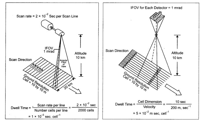
Whiskbroom Scanners: The whiskbroom scanners are made up of a rotating mirror and a single detector. The mirror is so oriented that when it completes a rotation, the detector sweeps across the field of view between 90° and 120° to obtain images in a large number of narrow spectral bands ranging from visible to middle infrared regions of the spectrum. The total extent of the oscillating sensor is known as the Total Field of View (TFOV) of the scanner. While scanning the entire field, the sensor’s optical head is always placed at a particular dimension called the Instantaneous Field of View (IFOV). Figure given below depicts the scanning mechanism of whiskbroom scanners.- In whiskbroom scanner, a single mirror is used to reflect light onto a single detector. The mirror moves back and forth to collect measurements from one pixel in the image at a time whereas in pushbroom scanner a line of detectors arranged in perpendicular to flight direction are used. The image is collected one line at a time with all of the pixels in a line measures simultaneously.
- A pushbroom scanner receives stronger signal than whiskbroom scanner because it looks at each pixel area for long.
- Pushbroom scanner is more sensitive than whiskbroom scanner. So it is needed to perfectly calibrate.
Question 3(ii).
Answer:
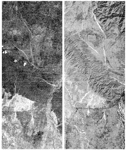
The Himalayan ranges show a succession of vegetation from the tropical to the tundra, with change in with the altitude. Deciduous forests are found in the foothills of the Himalayas. It is succeeded by the wet temperate type of forests between an altitude of 1,000-2,000 m. After 3000 metre altitude, conical forests are found which have sharp leaves. Important trees in this region are Chid, Fur, Pine, Sprus etc.The red patches in May image refer to Coniferous vegetation. In November image the additional red patches refer to Deciduous plants and the light red colour is related to the crops.
Class 11 Practical Work in Geography Chapter 7 NCERT Extra Questions
Class 11 Practical Work in Geography Chapter 7 Multiple Choice Questions
Question 1.
(a) Sensor
(b) False Colour Composite
(c) Spectral Band
(d) Electro-Magnetic Spectrum
Answer:
(c) Spectral BandQuestion 2.
(a) Band
(b) Digital Image
(c) Scene
(d) Spectrum
Answer:
(c) SceneQuestion 3.
(a) Reflectance
(b) False Colour Composite
(c) Spectral Band
(d) Electro Magnetic Spectrum
Answer:
(a) ReflectanceQuestion 4.
(a) Early 1950s
(b) Early 1960s
(c) Early 1970s
(d) Early 1980s
Answer:
(b) Early 1950sQuestion 5.
(a) Sun
(b) Generator
(c) Electronic Appliances
(d) Flash Gun
Answer:
(a) SunQuestion 6.
(a) Sensing
(b) Satellite images
(c) Bit-by-bit.
(d) Electromagnetic images
Answer:
(c) Bit-by-bitQuestion 7.
(а) Dispersion of Light
(б) Rainbow Principle
(c) Prism Principle
(d) Spectral Band
Answer:
(a) Dispersion of lightQuestion 8.
wavelength low frequency radio waves is called:
(a) Reflectance
(b) False Colour Composite
(c) Spectral Band
(d) Electro Magnetic Spectrum
Answer:
(d) Electro Magnetic SpectrumQuestion 9.
(a) Photographic Shadow
(b) Pixel
(c) Digital Number
(d) Algorithm
Answer:
(b) PixelQuestion 10.
(а) Sensor
(b) False Colour Composite
(c) Spectral Band
(d) Electro Magnetic Spectrum
Answer:
(b) False Colour CompositeClass 11 Practical Work in Geography Chapter 7 Very Short Answer Type Questions
Question 1.
Answer:
Remote sensing is the science of obtaining information about objects or areas from a distance, typically from aircraft or satellites.Question 2.
Answer:
Any imaging and non-imaging device that receives EMR and converts it into a signal that can be recorded and displayed as photographic or digital image.Question 3.
Answer:
It refers to an artificially generated colour image in which blue, green and red colours are assigned to the wavelengthregions to which they do not belong in nature. For example, in standard a False Colour Composite blue is assigned to green radiations (0.5 to 0.6 pm), green is assigned to red radiations (0.6 to 0.7 pm) and red is assigned to Near Infrared radiation (0.7 to 0.8 pm).
Question 4.
Answer:
A photographic sensor (camera) records the images of the objects at an instance of exposure.Question 5.
Answer:
The motor device which oscillates the scanning mirror through the angular field of view of the sensor and which determines the length of scan lines is called swath.Question 6.
Answer:
The oscillation of the scanning mirror across the scene directs the received energy to the detectors, where it is converted into electrical signals.Question 7.
Answer:
An image refers to pictorial representation, regardless of what regions of energy have been used to detect and record it. A photograph refers specifically to images that have been recorded on photographic film. Therefore, all images are not photographs but all photographs are images.Question 8.
Answer:
In satellite remote sensing, the sun-synchronous polar orbit enables the collection of images after a pre-determined periodical interval. This interval is referred to as the temporal resolution or the revisit time of the satellite over the same area of the earth surface.Class 11 Practical Work in Geography Chapter 7 Short Answer Type Questions
Question 1.
Answer:
A scanner is usually made up of a reception system consisting of a mirror and detectors. A scanning sensor constructs the scene by recording a series of scan lines. While doing so, the motor device oscillates the scanning mirror through the angular field of view of the sensor, which determines the length of scan lines and is called swath. It is because of such reasons that the mode of collection of images by scanners is referred bit-by-bit. Each scene is composed of cells that determine the spatial resolution of an image. The oscillation of the scanning mirror across the scene directs the received energy to the detectors, where it is converted into electrical signals. These signals are further converted into numerical values called Digital Number (DN Values) for recording on a magnetic tape.Question 2.
Answer:
Remote sensors are characterised by spatial, spectral and radiometric resolutions that enable the extraction of useful information pertaining to different terrain conditions.1. Spatial Resolution: Spatial resolution of the sensors refers to the capability of the sensor to distinguish two closed spaced object surfaces as two different object surfaces. As a rule, with an increasing resolution the identification of even smaller object surfaces become possible,
2. Spectral Resolution: It refers to the sensing and recording power of the sensor in different bands of EMR (Electromagnetic radiation). Multispectral images are acquired by using a device that disperses the radiation received by the sensor and recording it by deploying detectors sensitive to specific spectral ranges. The principles in obtaining such images is the extension of the dispersion of light in nature resulting in the appearance of the “rainbow”.
3.Radiometric Resolution: It is the capability of the sensor to discriminate between two targets. Higher the radiometric resolution, smaller the radiance differences that can be detected between two targets.
Question 3.
Answer:
We can group the characteristics of the objects into two broad categories, i.e. image characteristics and terrain characteristics.- Image Characteristics: The image characteristics include tone or colour in which objects appear, their shape, size, pattern, texture and the shadow they cast.
- Terrain Characteristics: Location and the association of different objects with their surrounding objects constitute the terrain characteristics.
Question 4.
(i) Photographs and images.
Answer:
| Basis | Photograph | Image |
| Meaning | A photograph refers specifically to images that have been recorded on photographic film. | An image refers to pictorial representation, regardless of what regions of energy have been used to detect and record it. |
| Scope | All photographs are images. Therefore it is inclusive in images and its scope is narrow. | All images are not photographs. Images can be: digital images and photographic images. Therefore, its scope is wider. |
(ii) Whiskbroom Scanners and Pushbroom Scanners.
Answer:
Whiskbroom scanners, also sometimes referred to as spotlight or across track scanners, use a mirror to reflect light onto a single detector. The mirror moves back and forth, to collect measurements from one pixel in the image at a time. It is shown below: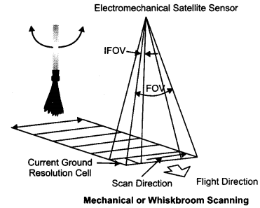
The moving parts make this type of sensor expensive and more likely to wear out.
Pushbroom Scanners:
Pushbroom scanners are also sometimes referred to as along track scanners. It is used a line of detectors arranged perpendicular to the flight direction of the spacecraft. As the spacecraft flies forward, the image is collected one line at a time, with all of the pixels in a line being measured simultaneously. It is shown with the help of following figure. A pushbroom scanner receives a stronger signal than a whiskbroom scanner because it looks at each pixel area for longer. One drawback of pushbroom sensors is that the detectors in the “pushbroom” can have varying sensitivity. If they are not perfectly calibrated, this can result in stripes in the data.
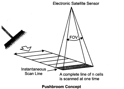
Sensors that use the push broom design include SPOT, IRS, QuickBird, OrbView etc.
(iii) Sun-synchronous (or polar) and geostationary orbits.
Answer:
| Basis | Sun-Synchronous | Geostationary Orbits |
| Location | Satellites in this orbit provide medium to high resolution images of the whole earth which are mostly used for environmental monitoring. They orbit at altitudes of 300 to 1,400 km above earth. | Geostationary orbits are located about 36,000 km above the earth. |
| Revolution time | With every satellite orbit which takes about 90 min, the earth is rotating a bit further resulting in the fact that the satellite is “watching” different sections of the earth in narrow bands. Days or weeks later, the satellite orbits again above the same section. | At this altitude a satellite needs exactly 24 hours to orbit around the earth, the same time the earth takes to perform a complete revolution around its axis. |
| Expansion | It is expaided from 81 degree north to 81 degree south latitude. | It is expanded on one third of the globe. |
| Example | The US LANDSAT series is a well known example of a polar orbiting satellite. | METEOSAT is one example for a geostationary satellite. |
| Utility | It is important for earth resources | It is important for telecommunication and weather department. |
(iv) Photographic and non-photographic sensors.
Answer:
| Basis | Photographic sensors | Non-photographic Sensors |
| Meaning | A photographic sensor (camera) records the images of the objects at an instance of exposure. | A non-photographic sensor obtains the images of the objects in bit-by-bit form. These sensors are known as scanners. |
| Device | It is done through camera | It is done through scanners |
| Other name | It is also called Analogue sensors | It is also called digital sensors. |
(v) Photographic image and digital image
Answer:
| Basis | Photographic Image | Digital Image |
| Meaning | Photographs are acquired in the optical regions of the electromagnetic spectrum, i.e. 0.3 – 0.9 pm. | A digital image consists of discrete picture elements called pixels. Each one of the pixels in an image has an intensity value and an address in two dimensional image space. |
| Colour | Four different types of light sensitive film emulsion bases are used to obtain photographs. These are black and white, colour, black and white infrared and colour infrared. | It does not require any film. |
Class 11 Practical Work in Geography Chapter 7 Long Answer Type Questions
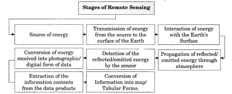
Question 1.
Answer:
Remote sensing help in the collection of information about the properties of the objects and phenomena of the earth surface:1. Source of Energy: Sun is the most important source of energy used in remote sensing.
2. Transmission of Energy from the Source to the Surface of the Earth:
The energy that emanates from a source propagates between the source and the object surface in the form of waves of energy at a speed of light (300,000 km per second). Such energy propagation is called Electromagnetic Radiation (EMR).
3. Interaction of Energy with the Earth’s Surface: The propagating energy finally interacts with the objects of the surface of the earth. This leads to absorption, transmission, reflection or emission of energy from the objects.
4. Propagation of Reflected/Emitted Energy through Atmosphere: When energy is reflected from objects of the earth’s surface, it re-enters into the atmosphere.
5. Detection of Reflected/Emitted Energy by the Sensor: The sensors recording the energy that they receive are placed in a near-polar sun-synchronous orbit at an altitude of 700 – 900 km. These satellites are known as remote sensing satellites (e.g. Indian Remote Sensing Series). As against these satellites, the weather monitoring and telecommunication satellites are placed in a Geostationary position (the satellite is always positioned over its orbit that synchronizes with the direction of the rotation of the earth) and revolves around the earth (coinciding with the direction of the movement of the earth over its axis) at an altitude of nearly 36,000 km (e.g. INSAT series of satellites).
6. Conversion of Energy Received into Photographic/Digital Form of Data: The radiations received by the sensor are electronically converted into a digital image. It comprises digital numbers that are arranged in rows and columns. These numbers may also be converted into an analogue (picture) form of data product. The sensor onboard an earth¬orbiting satellite electronically transmits the collected image data to an Earth Receiving Station located in different parts of the world.
7. Extraction of Information Contents from Data Products: After the image data is received at the earth station, it is processed for elimination of errors caused during image data collection. Once the image is corrected, information extraction is carried out from digital images using digital image processing techniques and from analogue form of data products by applying visual interpretation methods.
8. Conversion of Information into Map/Tabular Forms: The interpreted information is finally delineated and converted into different layers of thematic maps. Besides, quantitative measures are also taken to generate tabular data.
Question 2.
Answer:
In satellite remote sensing, the Multi-Spectral Scanners (MSS) are used assensors. These sensors are designed to obtain images of the objects while sweeping across the field of view.
The Multi-Spectral Scanners are divided into the following types:
- Whiskbroom Scanners
- Pushbroom Scanners
1. Whiskbroom Scanners: The whiskbroom scanners are made up of a rotating mirror and a single detector. The mirror is so oriented that when it completes a rotation, the detector sweeps across the field of view between 90° and 120° to obtain images in a large number of narrow spectral bands ranging from visible to middle infrared regions of the spectrum. The total extent of the oscillating sensor is known as the Total Field of View (TFOV) of the scanner. While scanning the entire field, the sensor’s optical head is always placed at a particular dimension called the Instantaneous Field of View (IFOV).
2. Pushbroom Scanners: The pushbroom scanners consist of a number of detectors which are equivalent to the number obtained by dividing the swath of the sensor by the size of the spatial resolution. In pushbroom scanner, all detectors are linearly arrayed and each detector collects the energy reflected by the ground cell (pixel) dimensions of 20 metres at a nadir’s view. For example, the swath of High-Resolution Visible Radiometer – 1 (HRVR – 1) of the French remote sensing satellite SPOT is 60 km and the spatial resolution is 20 metres. If we divide 60 km x 1000 metres/20 metres, we get a number of 3000 detectors that are deployed in SPOT HRV – 1 sensor.
Question 3.
Answer:
Based upon the mechanism used in detecting and recording, these may be broadly classified into two types:- Photographic Images
- Digital Images
1. Photographic Images: Photographs are acquired in the optical regions of electromagnetic spectrum, i.e. 0.3-0. 9 pm. Four different types of light sensitive film emulsion bases are used to obtain photographs. These are black and white, colour, black and white infrared and colour infrared. However, in aerial photography black and white film is normally used. Photographs may be enlarged to any extent without loosing information contents or the contrast.
2. Digital Images: A digital image consists of discrete picture elements called pixels. Each one of the pixels in an image has an intensity value and an address in two-dimensional image space. A digital number (DN) represents the average intensity value of a pixel. It is dependent upon the electromagnetic energy received by the sensor and the intensity levels used to describe its range. In a digital image, the reproduction of the details pertaining to the images of the objects is affected by the size of the pixel. A smaller size pixel is generally useful in the preservation of the scene details and digital representation. However, zooming of the digital image beyond certain extent produces loss of information and the appearance of pixels only. Using a digital image processing algorithms, the digital numbers representing their intensity level in an image may be displayed.
Question 4.
Answer:
Elements of Visual Interpretation Whether we are conscious of it or not we use the form, size, location of the objects and their relationships with the surrounding objects to identify them in our day-to-day life. These characteristics of objects are termed as elements of visual interpretation.1. Tone or Colour: All objects receive energy in all regions of spectrum. The interaction of EMR with the object surface leads to the absorption, transmittance and reflection of energy. It is the reflected amount of the energy that is received and recorded by the sensor in tones of grey, or hues of colour in black and white, and colour images respectively. The variations in the tone or the colour depend upon the orientation of incoming radiations, surface properties and the composition of the objects.
2. Texture: The texture refers to the minor variations in tones of grey or hues of colour. These variations are primarily caused by an aggregation of smaller unit features that fail to be discerned individually such as high density and low density residential areas; slums and squatter settlements; garbage and other forms of solid waste; and different types of crops and plants. The textural differences in the images of certain objects vary from smooth to coarse textures.
3. Size: The size of an object as discerned from the resolution or scale of an image is another important characteristic of individual objects. It helps in distinctively identifying the industrial and industrial complexes with residential dwellings.
4. Shape: The general form and configuration or an outline of an individual object provides important clues in the interpretation of remote sensing images. The shape of some of the objects is so distinctive that make them easy to identify. For example, the shape of the Sansad Bhawan is typically distinct from many other built- up features.
5. Shadow: Shadow of an object is a function of the sun’s illumination angle and the height of the object itself. The shape of some of the objects is so typical that they could not be identified without finding out the length of the shadow they cast. For example, the Question utub Minar located in Delhi, minarets of mosques, overhead water tanks, electric or telephone lines, and similar features can only be identified using their shadow.
6. Pattern: The spatial arrangements of many natural and man-made features show repetitive appearance of forms and relationships. The arrangements can easily be identified from the images through the utilisation of the pattern they form. For example, planned residential areas with the same size and layout plan of the dwelling units in an urban area can easily be identified if their pattern is followed.
7. Association: The association refers to the relationship between the objects and their surroundings along with their geographical location. For example, an educational institution always finds its association with its location in or near a residential area as well as the location of a playground within the same premises.
Class 11 Practical Work in Geography Chapter 7 Viva Questions
Question 1.
Answer:
It is the capability of the sensor to discriminate between two targets. Higher the radiometric resolution, smaller the radiance differences that can be detected between two targets.Question 2.
Answer:
Four different types of light sensitive film emulsion bases are used to obtain photographs. These are black and white, colour, black and white infrared and colour infrared.Question 3.
Answer:
A digital image consists of discrete picture elements called pixels. Each one of the pixels in an image has an intensity value and an address in two-dimensional image space. A digital number (DN) represents the average intensity value of a pixel.Question 4.
Answer:
The term remote sensing was first used in the early 1960s.Question 5.
Answer:
A sensor is a device that gathers electromagnetic radiations, converts it into a signal and presents it in a form suitable for obtaining information about the objects under investigation.Question 6.
Answer:
Based upon the form of the data output, the sensors are classified into two types:- Photographic Sensors (analogue) and
- Non-photographic (digital) sensors.
Question 7.
Answer:
A photographic sensor (camera) records the images of the objects at an instance of exposure. On the other hand, a non-photographic sensor obtains the images of the objects in bit-by-bit form. These sensors are known as scanners.Question 8.
Answer: Remote sensing is a better technique than traditional methods because it presents the concise picture of a large area; provides real or nearly real pictures on time base line, it is less expensive as compared to land survey and we can easily collect information by using it. It converts energy received into photographic/digital form of data. It is not affected by bad weather and inaccessible land.
Introduction to Remote Sensing Notes
- The term remote sensing was first used in the early 1960s.
- A sensor is a device that gathers electromagnetic radiations, converts it into a signal and presents it in a form suitable for obtaining information about the objects under investigation.
- Based upon the form of the data output, the sensors are classified into two types:
- Photographic Sensors (analogue) and
- Non-photographic (digital) sensors.
- A photographic sensor (camera) records the images of the objects at an instance of exposure. On the other hand, a non-photographic sensor obtains the images of the objects in bit-by-bit form. These sensors are known as scanners.
- In satellite remote sensing, the Multi Spectral Scanners (MSS) are used as sensors. These sensors are designed to obtain images of the objects while sweeping across the field of view.
- The Multi Spectral Scanners are divided into the following types:
- Whiskbroom Scanners
- Pushbroom Scanners.
- Based upon the mechanism used in detecting and recording, the remotely sensed data products may be broadly classified into two types:
- Photographic Images
- Digital Images
- Four different types of light sensitive film emulsion bases are used to obtain photographs. These are black and white, colour, black and white infrared and colour infrared. However, in aerial photography black and white film is normally used. Photographs may be enlarged to any extent without losing information contents or the contrast.
- Intentionally or unintentionally, we use the form, size, location of the objects and their relationships with the surrounding objects to identify them in our day-to-day life. These characteristics of objects are termed as elements of visual interpretation.
- both qualitative and quantitative properties of such features could be carried out using either visual interpretation methods or digital image processing techniques.
- Electromagnetic energy may be detected either photographically or electronically. The photographic process uses light sensitive film to detect and record energy variations. On the other hand, a scanning device obtains images in digital mode.
Introduction to Remote Sensing Important terms
- Absorbance: The ratio of the radiant energy absorbed by a substance to the energy it receives is called absorbance.
- Remote Sensing: It is defined as the total processes used to acquire and measure the information of some property of objects and phenomena by a recording device (sensor) that is not in physical contact with the objects and phenomena in study.
- Band: The specific wavelength interval in the electromagnetic spectrum is called band.
- Digital image: An array of digital numbers (DN) arranged in rows and columns which are having the property of an intensity value and their locations is termed as digital image.
- Digital Number: An intensity value of a pixel in a digital image is called digital number.
- Digital Image Processing: The numerical manipulation of digital numbers values for the purpose of extracting information about the phenomena of the surface they represent is termed as digital image processing.
- Pixel: A digital image consists of discrete picture elements called pixels. Each one of the pixels in an image has an intensity value and an address in two-dimensional image space.
- Electromagnetic Radiation (EMR): The Energy propagated through a space or a medium at a speed of light is called electromagnetic radiation.
- Electromagnetic Spectrum: The continuum of electromagnetic radiation that ranges from short wave high frequency cosmic radiations to long-wavelength low-frequency radio waves.
- Multispectral Scanners: In satellite remote sensing, the Multi-Spectral Scanners (MSS) are used as sensors. These sensors are designed to obtain images of the objects while sweeping across the field of view.
- TFOV: The total extent of the oscillating sensor is known as the Total Field of View (TFOV) of the scanner.
- IFOV: While scanning the entire field, the sensor’s optical head is always placed at a particular dimension called the Instantaneous Field of View (IFOV).
- False Colour Composite (FCC): An artificially generated colour image in which blue, green and red colours are assigned to the wavelength regions to which they do not belong in nature.
- Gray scale: A medium to calibrate the variations in the brightness of an image that ranges from black to white with intermediate grey values is called gray scale.
- Image: It is the permanent record of a scene comprising of natural and man-made features and activities, produced by photographic and non-photographic means.
- Scene: The ground area covered by an image or a photograph is called a scene.
- Swath: The motor device which oscillates the scanning mirror through the angular field of view of the sensor, which determines the length of scan lines is called swath.
- Sensor: A sensor is a device that gathers electromagnetic radiations, converts it into a signal and presents it in a form suitable for obtaining information about the objects under investigation.
- Reflectance: It is the ratio of the radiant energy reflected by a substance to the energy it receives. ‘
- Spectral Band: It is the range of the wavelengths in the continuous spectrum such as the green band ranges from 0.5 to 0.6 p and the range of NIR band 0.7 to 1.1 p.
NCERT Class 11 Geography (Practical Work in Geography)
Class 11 Geography Chapters | Geography Class 11 Chapter 7
NCERT Class 11 Fundamentals of Physical Geography Solutions
NCERT Solutions for Class 11 Geography: Fundamentals of Physical Geography
-
NCERT Solutions For Class 11 Geography Chapter 1 Geography as a Discipline
NCERT Solutions For Class 11 Geography Chapter 2 The Origin and Evolution of the Earth
NCERT Solutions For Class 11 Geography Chapter 3 Interior of the Earth
NCERT Solutions For Class 11 Geography Chapter 4 Distribution of Oceans and Continents
NCERT Solutions For Class 11 Geography Chapter 5 Minerals and Rocks
NCERT Solutions For Class 11 Geography Chapter 6 Geomorphic Processes
NCERT Solutions For Class 11 Geography Chapter 7 Landforms and their Evolution
NCERT Solutions For Class 11 Geography Chapter 8 Composition and Structure of Atmosphere
NCERT Solutions For Class 11 Geography Chapter 9 Solar Radiation, Heat Balance and Temperature
NCERT Solutions For Class 11 Geography Chapter 10 Atmospheric Circulation and Weather Systems
NCERT Solutions For Class 11 Geography Chapter 11 Water in the Atmosphere
NCERT Solutions For Class 11 Geography Chapter 12 World Climate and Climate Change
NCERT Solutions For Class 11 Geography Chapter 13 Water (Oceans)
NCERT Solutions For Class 11 Geography Chapter 14 Movements of Ocean Water
NCERT Solutions For Class 11 Geography Chapter 15 Life on the Earth
NCERT Solutions For Class 11 Geography Chapter 16 Biodiversity and Conversation
NCERT Class 11 India Physical Environment Solutions
NCERT Solutions for Class 11 Geography: India Physical Environment
-
NCERT Solutions For Class 11 Geography Chapter 1 India: Location
NCERT Solutions For Class 11 Geography Chapter 2 Structure and Physiography
NCERT Solutions For Class 11 Geography Chapter 3 Drainage System
NCERT Solutions For Class 11 Geography Chapter 4 Climate
NCERT Solutions For Class 11 Geography Chapter 5 Natural Vegetation
NCERT Solutions For Class 11 Geography Chapter 6 Soils
NCERT Solutions For Class 11 Geography Chapter 7 Natural Hazards and Disasters
Practical Work in Geography Class 11 Solutions
NCERT Solutions for Class 11 Geography: Practical Work in Geography
-
NCERT Solutions For Class 11 Geography Chapter 1 Introduction to Maps
NCERT Solutions For Class 11 Geography Chapter 2 Map Scale
NCERT Solutions For Class 11 Geography Chapter 3 Latitude, Longitude and Time
NCERT Solutions For Class 11 Geography Chapter 4 Map Projections
NCERT Solutions For Class 11 Geography Chapter 5 Topographical Maps
NCERT Solutions For Class 11 Geography Chapter 6 Introduction to Aerial Photographs
NCERT Solutions For Class 11 Geography Chapter 7 Introduction to Remote Sensing
NCERT Solutions For Class 11 Geography Chapter 8 Weather Instruments, Maps and Charts
Post a Comment
इस पेज / वेबसाइट की त्रुटियों / गलतियों को यहाँ दर्ज कीजिये
(Errors/mistakes on this page/website enter here)