
NCERT Solutions | Class 11 Geography (Fundamentals of Physical Geography) Chapter 7 | Landforms and their Evolution

CBSE Solutions | Geography Class 11
Check the below NCERT Solutions for Class 11 Geography (Fundamentals of Physical Geography) Chapter 7 Landforms and their Evolution Pdf free download. NCERT Solutions Class 11 Geography were prepared based on the latest exam pattern. We have Provided Landforms and their Evolution Class 11 Geography NCERT Solutions to help students understand the concept very well.
NCERT | Class 11 Geography (Fundamentals of Physical Geography)
| Book: | National Council of Educational Research and Training (NCERT) |
|---|---|
| Board: | Central Board of Secondary Education (CBSE) |
| Class: | 11 |
| Subject: | Geography |
| Chapter: | 7 |
| Chapters Name: | Landforms and their Evolution |
| Medium: | English |
Landforms and their Evolution | Class 11 Geography | NCERT Books Solutions
Important Questions for Class 11 Geography Chapter 7 Landforms and their Evolution
Landforms and their Evolution Important Extra Questions Very Short Answer Type
Question 1.
Answer:
It is the study of landforms especially concerned with the genesis, evolution, and processes involved in the formation of the surface features of the earth.Question 2.
Answer:
The physical landscape of the earth’s surface is called relief. It includes mountains, valleys, plains, and plateaus.Question 3.
Answer:
Chemical weathering, mechanical weathering, and biological weathering.Question 4.
Answer:
Rill, gully, stream, river.Question 5.
Answer:
When a glacial trough formed near the sea gets filled up by the seawater, it is called a fiord. It is a deep steep-sided water inlet near the sea.Question 6.
Answer:
Mud-flow is a moving mass of solid waste fluid by rain or melting snow.Question 7.
Answer:
Deflation is the lifting and transporting of loose particles of clay and silt, collectively referred to as dust.Question 8.
Answer:
The landform is the shape, focus and volume of a specific physical feature of the earth’s surface produced by natural processes of erosion and deposition.Question 9.
Answer:
A combination is a form of chemical weathering caused due to the reaction of minerals with dissolved carbon dioxide in water.Question 10.
Answer:
As a geomorphic agent, the running water acts in two basic forms, namely overland flow and channel or streamflow.Question 11.
Answer:
The drainage basin is a part of land drained by a sole river system.Question 12.
Answer:
Rivers perform three closely inter-related geomorphic works, viz., erosion, transportation, and deposition.Question 13.
Answer:
The valley of the Chambal in Madhya Pradesh is an example of badland topography.Question 14.
Answer:
Karst topography is a landscape formed by groundwater in a limestond1 region.Question 15.
Answer:
The top of the zone of saturated rocks is called the water table.Question 16.
Answer:
Wind action is most prominent in arid and semi-arid areas as there are loose particles of soil in these areas and wind can remove them easily.Question 17.
Answer:
The following areas on the earth’s surface depict landforms made by glaciers:- High altitude areas,
- High mountain areas.
Question 18.
Answer:
The moving heap of ice and snow is termed a glacier.Question 19.
Answer:
Lagoons are formed when sand bars along the coast cut off a portion of the sea from the main water body. Example:- Chilka lake (in Orissa),
- Pullicat lake (Tamilnadu).
Question 20.
Answer:
- Areas or regions situated at high latitudes.
- Areas situated at very high altitudes irrespective of their distance from the equator.
Question 21.
Answer:
Loose pieces of rocks and sand suspended in the sea waves.Question 22.
Answer:
Marine erosion is the erosion of rocks in the coastal areas, carried out by the sea waves.Question 23.
Answer:
On the Malabar coast of India.Question 24.
Answer:
Marine beach is situated in Chennai on the Coromandel coast.Question 25.
Answer:
4 kilometres per day.Question 26.
Answer:
In arid and semi-arid regions.Question 27.
Answer:
- Wind eroded basin,
- Loess plains,
- Sand dunes.
Question 28.
Answer:
Sand dunes originate at the place where there is some obstruction in the way of the wind.Landforms and their Evolution Important Extra Questions Short Answer Type
Question 1.
Answer:
- Sun always shines perpendicular on the equator. Hence, equatorial regions get intense heat due to straight sun rays. As we go northwards or southwards from the equator, the sun’s rays become oblique and less heat is received in these regions. Hence, poles are always cold.
- Temperature decreases with increase in height at the rate of 1 °C per 165 metres height. Hence, as we go above from the equator, fewer temperatures are observed. A height comes when the temperature is below freezing point and snow and ice rules over.
Question 2.
Answer:
The vast areas which are permanently covered with snow and ice are called snowfields.The snowfields are generally found situated above the snow line.
- High latitudes and polar regions,
- Near mountain tops.
Question 3.
Answer:
Glaciers carry pieces of rocks, big and small, with them. They deposit them at certain places – at their edges, on the bottom, at the terminals and the central zone of two glaciers. These deposits are called moraines.Question 4.
Answer:
Loess is the deposit of sand blown over long distances and deposited over large areas. When the thickness of the loess is hundreds of metres, it assumes the name of loess plateau.Question 5.
Answer:
Wind deposits sand brought by it as sand dunes. The major features of these sand dunes are as follows:- A sand dune is a typical hill. It has a crest.
- It is generally mobile as it goes on shifting along the direction of the prevailing wind.
- Obstructions in the path of the wind lead to the formation of the sand dunes.
- Sand dunes vary in size. They vary from a few metres to 300 metres in height.
Question 6.
Answer:
| Stalactite | Stalagmite |
| Deposits of lime hanging downwards from the ceiling are of a cave are called stalactites | deposits of lime taking place upwards from the floor of an ave are termed as stalagmites. |
Question 7.
Answer:
| Beaches | Sand Bars |
| (1) Beaches. are deposits of sand and gravel along the coast. | (1) Sand bars are embank¬ments of sand and gravel built by the wave action on the seafloor at a short distance from the coast, |
| (2) Example: Marine beach in Chennai. | (2) Example: Sand bars along the coast of Kerala. |
Question 8.
Answer:
When a glacial trough formed near the sea gets filled up by the seawater, it is called a fiord. Thus a fiord is a deep, steep-sided water inlet near the sea. It is typical of Norwegian and Chilean coasts.Question 9.
Answer:
Regolith is a layer of loose or soft material lying above the bedrock. When regolith is formed by decomposition and disintegration of the bedrock that lies directly beneath it, it is called residual regolith. The regolith transported by steam, ice, water and deposited elsewhere is called transported regolith.Question 10.
Answer:
Running water is undoubtedly the most important agent of denudation. It is most conspicuous as a stream or river that transports enormous volumes of surplus precipitation from the land to the ocean. Stream action, in combination with weathering, mass wasting and overland flow, is responsible for the total process called fluvial denudation.Question 11.
Answer:
Running water acts as a geomorphic agent in two basic forms, viz., overland flow and channel or streamflow.Overland flow is the movement of run-off downhill on the ground surface in a more or less broadly distributed sheet or film. Second is channel flow or streamflow in which water moves to lower levels in a long, narrow, trough-like feature called stream-channel, bounded on both sides by rising shapes called banks that contain the flow.
Question 12.
Answer:
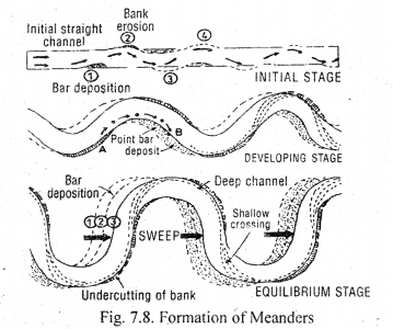
Gentle rain falling on bare surfaces loosens the soil and muddies the water. The muddy water flows as the thin, slow-moving surface layer of water called sheet flow. As the slope increases, the water scours additional sediments and erodes small channels, which are called rills. Headward erosion of rills and their subsequent widening leads to gully formation. Gullies dissect the land into a number of isolated hills, giving rise to badland topography.Question 13.
Answer:
A host of internal and external forces are involved in the creation of landforms. Tectonic forces crumple rocks and push up continents and mountain ranges. Moving water, air and ice erode rocks and transport the eroded debris to depositional sites and thus change the appearance of the landscape with the passage of time. The intensity of these agencies varies from one region to- another depending on climate, vegetation and altitude.Question 14.
Answer:
A glacier does not make its own valley. When a glacier enters a V-shaped river valley, it modifies it into a U-shaped valley. The valley is deepened as the pressure of ice increases. A wide, flat structure is formed. Due to side cutting the valley is widened, and it is known as U-shaped valley.Question 15.
Answer:
The erosional work of the river depends upon the following factors:- Volume of water
- The slope of the river
- Load of the river
- Velocity of water
- The nature of the rocks
Landforms and their Evolution Important Extra Questions Long Answer Type
Question 1.
Answer:
At the shoreline, the line along which the water meets the land, the major erosive agent is wave action. Along the coast of hard rock, a gently inclined rock surface is carved out to accommodate the swash and backwash. It is called abrasion platform. A shoreline rising abruptly from the abrasion platform is called a marine cliff. The stormy waves thrust rock fragments with great violence against the cliff base to develop wave-cut notches or sea-caves. Relatively thick and gently sloping accumulation of sand, gravel or cobbles in the zone of breakers and surf is called beads.
Question 2.
Answer:
Rivers are the stream channels organised into branching channel network. Rivers perform three closely interacted geomorphic works, viz.,- erosion,
- transportation,
- deposition. River erosion is the progressive removal of minerals from the surface of stream channel which itself may consist of the bedrock of regolith. River transportation is the movement of eroded particles in a chemical solution, in turbulent suspension or 6y rolling and changing along the bed. River deposition consists of -accumulation of any transported particles on the stream bed on the adjoining flood plain or on the floor of a body of standing water into which the river empties. While the river performs all three functions simultaneously, one may dominate over the other in different parts of the river course.
The nature of river erosion depends upon the materials of which the channel is composed. Erosion is hydraulic action, the pressure and drag of flowing water exerted upon grains projecting from the bed and banks. Weak bedrock and various forms of regolith are easily carved out by hydraulic action. Abrasion occurs when rock particles carried in the current strike against the exposed bedrock of the channel. Small particles are reduced by crushing and grinding when caught between larger cobbles and boulders. The chemical reaction between ions carried in solution and exposed mineral surfaces result in a form of erosion called a solution.
Question 3.
Answer:
Winds are not strong enough to remove the mineral matter from hard rocks, moist clay or soil rich in vegetation. They can only affect those rocks which are soft, arid and vegetation less. Hence rocks which are soft are eroded the fastest.Formation of landforms by winds: Winds form landforms both during erosional and depositional work.
Erosional landforms – Winds erode loose particles of soil and take them away. In course of a time, a hollow is formed in the desert surface. This is called a wind-eroded basin.
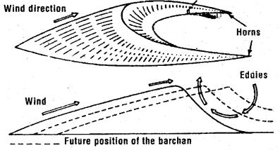
Depositional landforms – When the wind becomes weak and some obstacle lies in its path, deposition of transported loose particles begin to take place. Wind becomes weak due to the decrease in its velocity. As a result of the depositions, sand dunes are formed. They are of different types and shapes.

Question 4.
Answer:
The most important agent modifying coastal topography is sea waves. Sea waves erode, transport and deposit debris in the coastal regions and form both erosional as well as depositional features,Erosional Features: Arches and Sea stacks: If the rock formation along the coast differs in resistance, softer rocks are eroded and harder remain to stand. This results in the formation of arches and stacks.
Depositional Features:
- Sea waves deposit sand, gravel and pebbles on the shore. These deposits are called beaches. Marine beach (Triplicane) in Chennai is famous in India.
- Sometimes sea waves deposit embankments of sand and gravel on the seafloor not far from the coast. These embankments are termed as bars. Very often ships strike against these bars and cause damage to themselves.
- Sometimes sand bars separate a portion of the sea from the main sea, giving birth to a lake lagoon. A lagoon is a saltwater .lake. These lakes have a connection with the main sea through sand and gravel along with the narrow outlets. Malabar coast in India abounds in lagoons. On the eastern coast, Chilka (in Orissa) and Pullicat (near Chennai) are two well-known lagoons.

Question 5.
1. V-shaped valley and U-shaped valley.
2. Valley glacier and Continental glacier.
3. Gorge and Canyon.
Answer:
1. V-shaped valley and U-shaped valley.| V-shaped valley | U-shaped valley |
| (1) Valley with slanting sides and the narrow bottom is called a V-shaped valley. | (1) Valley with steep sides and flat bottom is called a U-shaped valley. |
| (2) It is formed by the action of running water. | (2) It is formed by the action of the glacier. |
| (3) Example: Ganga, Brahmputra valley. | (3) Valley formed by Pindari glacier in the Himalayas. |
2. Valley glacier and Continental glacier.
| Valley glacier | Continental glacier |
| (1) Glaciers formed in the high mountains are long and narrow as they occupy former river valley, and are termed as valley glacier. | (1) Glaciers formed in polar and arctic regions over extensive areas are called continental glaciers. |
| (2) Example: Siachen glacier. | (2) Example: Antarctic glacier. |
3. Gorge and Canyon.
| Gorge | Canyon |
| (1) A gorge is a narrow deep opening of the river across a mountain. | (1) Canyon are formed in dry areas. |
| (2) Side cuttings are absent due to hard rocks. | (2) It has high vertical walls for long distances. |
| (3) The river’s downcutting leads to the formation of deep gorges | (3) The upper part of the canyon is wide due to weathering. |
| (4) The lower part is deeper due to rapid downcutting |
NCERT Class 11 Geography (Fundamentals of Physical Geography)
Class 11 Geography Chapters | Geography Class 11 Chapter 7
NCERT Class 11 Fundamentals of Physical Geography Solutions
NCERT Solutions for Class 11 Geography: Fundamentals of Physical Geography
-
NCERT Solutions For Class 11 Geography Chapter 1 Geography as a Discipline
NCERT Solutions For Class 11 Geography Chapter 2 The Origin and Evolution of the Earth
NCERT Solutions For Class 11 Geography Chapter 3 Interior of the Earth
NCERT Solutions For Class 11 Geography Chapter 4 Distribution of Oceans and Continents
NCERT Solutions For Class 11 Geography Chapter 5 Minerals and Rocks
NCERT Solutions For Class 11 Geography Chapter 6 Geomorphic Processes
NCERT Solutions For Class 11 Geography Chapter 7 Landforms and their Evolution
NCERT Solutions For Class 11 Geography Chapter 8 Composition and Structure of Atmosphere
NCERT Solutions For Class 11 Geography Chapter 9 Solar Radiation, Heat Balance and Temperature
NCERT Solutions For Class 11 Geography Chapter 10 Atmospheric Circulation and Weather Systems
NCERT Solutions For Class 11 Geography Chapter 11 Water in the Atmosphere
NCERT Solutions For Class 11 Geography Chapter 12 World Climate and Climate Change
NCERT Solutions For Class 11 Geography Chapter 13 Water (Oceans)
NCERT Solutions For Class 11 Geography Chapter 14 Movements of Ocean Water
NCERT Solutions For Class 11 Geography Chapter 15 Life on the Earth
NCERT Solutions For Class 11 Geography Chapter 16 Biodiversity and Conversation
NCERT Class 11 India Physical Environment Solutions
NCERT Solutions for Class 11 Geography: India Physical Environment
-
NCERT Solutions For Class 11 Geography Chapter 1 India: Location
NCERT Solutions For Class 11 Geography Chapter 2 Structure and Physiography
NCERT Solutions For Class 11 Geography Chapter 3 Drainage System
NCERT Solutions For Class 11 Geography Chapter 4 Climate
NCERT Solutions For Class 11 Geography Chapter 5 Natural Vegetation
NCERT Solutions For Class 11 Geography Chapter 6 Soils
NCERT Solutions For Class 11 Geography Chapter 7 Natural Hazards and Disasters
Practical Work in Geography Class 11 Solutions
NCERT Solutions for Class 11 Geography: Practical Work in Geography
-
NCERT Solutions For Class 11 Geography Chapter 1 Introduction to Maps
NCERT Solutions For Class 11 Geography Chapter 2 Map Scale
NCERT Solutions For Class 11 Geography Chapter 3 Latitude, Longitude and Time
NCERT Solutions For Class 11 Geography Chapter 4 Map Projections
NCERT Solutions For Class 11 Geography Chapter 5 Topographical Maps
NCERT Solutions For Class 11 Geography Chapter 6 Introduction to Aerial Photographs
NCERT Solutions For Class 11 Geography Chapter 7 Introduction to Remote Sensing
NCERT Solutions For Class 11 Geography Chapter 8 Weather Instruments, Maps and Charts
Post a Comment
इस पेज / वेबसाइट की त्रुटियों / गलतियों को यहाँ दर्ज कीजिये
(Errors/mistakes on this page/website enter here)